Weather Alert in Florida
Flood Warning issued August 25 at 9:06PM EDT until August 28 at 2:00PM EDT by NWS Melbourne FL
AREAS AFFECTED: Lake, FL; Volusia, FL
DESCRIPTION: ...The Flood Warning continues for the following rivers in Florida... St Johns River Near Astor affecting Volusia and Lake Counties. .Heavy rain and saturated soils in the Middle Saint Johns basin have led to a steady rise in river levels near Astor. Levels are forecast to slowly rise to Minor Flood Stage within the next day, and remain steady through mid to late week. For the St. Johns River...including Astor...Minor flooding is forecast. Additional information is available at www.weather.gov. The next statement will be issued Tuesday afternoon at noon EDT. * WHAT...Minor flooding is forecast. * WHERE...St Johns River near Astor. * WHEN...From Tuesday morning to early Thursday afternoon. * IMPACTS...At 2.3 feet, Many docks become submerged along the river and in canals in the Astor community. Water enters yards of properties on Bartram Road, Holiday Circle and along Wild Hog Road on the Lake County side. In Volusia County, water encroaches yards of homes on the river side of Alice Drive. No wake zones are in effect from near the South Moon Canal to approximately 800 feet south of the Riverview lodge. * ADDITIONAL DETAILS... - At 8:30 PM EDT Monday the stage was 2.2 feet. - Bankfull stage is 2.0 feet. - Forecast...The river is expected to rise to a crest of 2.3 feet tomorrow morning. It will then fall below flood stage Thursday morning. - Flood stage is 2.3 feet. - http://www.weather.gov/safety/flood
INSTRUCTION: N/A
Want more detail? Get the Complete 7 Day and Night Detailed Forecast!
Current U.S. National Radar--Current
The Current National Weather Radar is shown below with a UTC Time (subtract 5 hours from UTC to get Eastern Time).

National Weather Forecast--Current
The Current National Weather Forecast and National Weather Map are shown below.

National Weather Forecast for Tomorrow
Tomorrow National Weather Forecast and Tomorrow National Weather Map are show below.

North America Water Vapor (Moisture)
This map shows recent moisture content over North America. Bright and colored areas show high moisture (ie, clouds); brown indicates very little moisture present; black indicates no moisture.

Weather Topic: What is Fog?
Home - Education - Cloud Types - Fog
 Next Topic: Fractus Clouds
Fog is technically a type of stratus cloud, which lies along the
ground and obscures visibility.
It is usually created when humidity in the air condenses into tiny water droplets.
Because of this, some places are more prone to foggy weather, such as regions
close to a body of water.
Fog is similar to mist; both are the appearance of water droplets suspended in
the air, but fog is the term applied to the condition when visibility is less than 1 km.
Next Topic: Fractus Clouds
Weather Topic: What is Freezing Rain?
Home - Education - Precipitation - Freezing Rain
 Next Topic: Graupel
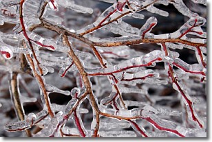
Freezing rain is a condition where precipitation which has fallen in the form of
water droplets reaches temperatures which are below freezing and freezes upon
coming into contact
with surface objects. The result of this precipitation is a glaze of ice which
can be damaging to plants and man-made structures. A severe onset of freezing
rain which results in a very thick glaze of ice is known as an ice storm.
Next Topic: Graupel
Current conditions powered by WeatherAPI.com


