Weather Alert in Arizona
Dust Storm Warning issued September 2 at 5:04PM MST until September 2 at 6:00PM MST by NWS Las Vegas NV
AREAS AFFECTED: Mohave, AZ
DESCRIPTION: The National Weather Service in Las Vegas has issued a * Dust Storm Warning for... West central Mohave County in northwestern Arizona... * Until 600 PM MST. * At 503 PM MST, dust storm conditions were occurring on Pierce Ferry Road north of Dolan Springs, or 34 miles north of Kingman, moving west at 35 mph. HAZARD...Less than a quarter mile visibility with strong wind in excess of 50 mph. SOURCE...Detected by National Weather Service meteorologists. IMPACT...Dangerous life-threatening travel. * Highway 93 will see poor visibility in blowing dust. Locations impacted include... Dolan Springs.
INSTRUCTION: Dust storms lead to dangerous driving conditions with visibility reduced to near zero. If driving, avoid dust storms if possible. If caught in one, pull off the road, turn off your lights and keep your foot off the brake.
Want more detail? Get the Complete 7 Day and Night Detailed Forecast!
Current U.S. National Radar--Current
The Current National Weather Radar is shown below with a UTC Time (subtract 5 hours from UTC to get Eastern Time).

National Weather Forecast--Current
The Current National Weather Forecast and National Weather Map are shown below.

National Weather Forecast for Tomorrow
Tomorrow National Weather Forecast and Tomorrow National Weather Map are show below.

North America Water Vapor (Moisture)
This map shows recent moisture content over North America. Bright and colored areas show high moisture (ie, clouds); brown indicates very little moisture present; black indicates no moisture.

Weather Topic: What are Contrails?
Home - Education - Cloud Types - Contrails
 Next Topic: Cumulonimbus Clouds
A contrail is an artificial cloud, created by the passing of an
aircraft.
Contrails form because water vapor in the exhaust of aircraft engines is suspended
in the air under certain temperatures and humidity conditions. These contrails
are called exhaust contrails.
Another type of contrail can form due to a temporary reduction in air pressure
moving over the plane's surface, causing condensation.
These are called aerodynamic contrails.
When you can see your breath on a cold day, it is also because of condensation.
The reason contrails last longer than the condensation from your breath is
because the water in contrails freezes into ice particles.
Next Topic: Cumulonimbus Clouds
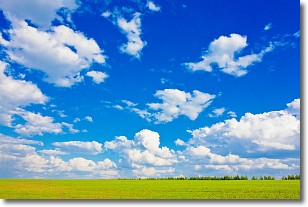
Weather Topic: What are Cumulus Clouds?
Home - Education - Cloud Types - Cumulus Clouds
 Next Topic: Drizzle
Cumulus clouds are fluffy and textured with rounded tops, and
may have flat bottoms. The border of a cumulus cloud
is clearly defined, and can have the appearance of cotton or cauliflower.
Cumulus clouds form at low altitudes (rarely above 2 km) but can grow very tall,
becoming cumulus congestus and possibly the even taller cumulonimbus clouds.
When cumulus clouds become taller, they have a greater chance of producing precipitation.
Next Topic: Drizzle
Current conditions powered by WeatherAPI.com


