Weather Alert in Colorado
Winter Storm Watch issued May 5 at 3:00AM MDT until May 7 at 6:00AM MDT by NWS Denver CO
AREAS AFFECTED: South and East Jackson/Larimer/North and Northeast Grand/Northwest Boulder Counties Above 9000 Feet; South and Southeast Grand/West Central and Southwest Boulder/Gilpin/Clear Creek/Summit/North and West Park Counties Above 9000 Feet
DESCRIPTION: * WHAT...Heavy snow possible. Total snow accumulations 12 to 22 inches possible, heaviest amounts on the crest and eastern slopes of the Front Range. Much lighter snow in valleys of Summit County to Vail Pass. * WHERE...Rocky Mountain National Park and the Medicine Bow Range, and The Mountains of Summit County, the Mosquito Range, and the Indian Peaks. * WHEN...From Tuesday morning through late Tuesday night. * IMPACTS...Travel could be very difficult, including I-70 east of the Eisenhower Tunnel, the Peak to Peak Highway, US40 and Berthoud Pass area, and Highway 14 over and east of Cameron Pass. The hazardous conditions will impact the late Tuesday morning and Tuesday evening commutes. * ADDITIONAL DETAILS...Some snow will fall this afternoon and tonight, and slush/snow can be expected on the higher passes. More significant travel impacts can be expected Tuesday and Tuesday night.
INSTRUCTION: Monitor the latest forecasts for updates on this situation.
Want more detail? Get the Complete 7 Day and Night Detailed Forecast!
Current U.S. National Radar--Current
The Current National Weather Radar is shown below with a UTC Time (subtract 5 hours from UTC to get Eastern Time).

National Weather Forecast--Current
The Current National Weather Forecast and National Weather Map are shown below.

National Weather Forecast for Tomorrow
Tomorrow National Weather Forecast and Tomorrow National Weather Map are show below.

North America Water Vapor (Moisture)
This map shows recent moisture content over North America. Bright and colored areas show high moisture (ie, clouds); brown indicates very little moisture present; black indicates no moisture.

Weather Topic: What is Condensation?
Home - Education - Precipitation - Condensation
 Next Topic: Contrails
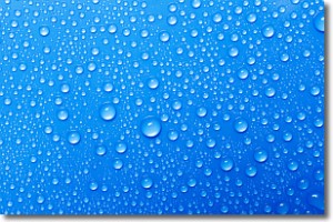
Condensation is the process which creates clouds, and therefore
it is a crucial process in the water cycle.
Condensation is the change of matter from a state of gas into a state of liquid,
and it happens because water molecules release heat into the atmosphere and
become organized into a more closely packed structure, what we might see as
water droplets.
Water is always present in the air around us as a vapor, but it's too small for
us to see. When water undergoes the process of condensation it becomes organized
into visible water droplets. You've probably seen condensation happen before on the
surface of a cold drink!
Next Topic: Contrails
Weather Topic: What are Cumulonimbus Clouds?
Home - Education - Cloud Types - Cumulonimbus Clouds
 Next Topic: Cumulus Clouds
The final form taken by a growing cumulus cloud is the
cumulonimbus cloud, which is very tall and dense.
The tower of a cumulonimbus cloud can soar 23 km into the atmosphere, although
most commonly they stop growing at an altitude of 6 km.
Even small cumulonimbus clouds appear very large in comparison to other cloud types.
They can signal the approach of stormy weather, such as thunderstorms or blizzards.
Next Topic: Cumulus Clouds
Current conditions powered by WeatherAPI.com


