Weather Alert in Kansas
Severe Thunderstorm Warning issued August 3 at 7:49PM CDT until August 3 at 8:45PM CDT by NWS Dodge City KS
AREAS AFFECTED: Clark, KS; Comanche, KS; Ford, KS; Kiowa, KS; Meade, KS
DESCRIPTION: SVRDDC The National Weather Service in Dodge City has issued a * Severe Thunderstorm Warning for... Southeastern Ford County in southwestern Kansas... Southwestern Kiowa County in south central Kansas... Eastern Meade County in southwestern Kansas... Western Comanche County in south central Kansas... Clark County in southwestern Kansas... * Until 845 PM CDT. * At 748 PM CDT, a severe thunderstorm was located near Minneola, moving south at 35 mph. THIS IS A DESTRUCTIVE STORM FOR Ford, Kingsdown, Clark State Lake. HAZARD...90 mph wind gusts and quarter size hail. SOURCE...Radar indicated. IMPACT...You are in a life-threatening situation. Flying debris may be deadly to those caught without shelter. Mobile homes will be heavily damaged or destroyed. Homes and businesses will have substantial roof and window damage. Expect extensive tree damage and power outages. * Locations impacted include... Englewood.
INSTRUCTION: This is a DANGEROUS SITUATION. This storm is producing widespread wind damage across Ford county. SEEK SHELTER NOW inside a sturdy structure and stay away from windows!
Want more detail? Get the Complete 7 Day and Night Detailed Forecast!
Current U.S. National Radar--Current
The Current National Weather Radar is shown below with a UTC Time (subtract 5 hours from UTC to get Eastern Time).

National Weather Forecast--Current
The Current National Weather Forecast and National Weather Map are shown below.

National Weather Forecast for Tomorrow
Tomorrow National Weather Forecast and Tomorrow National Weather Map are show below.

North America Water Vapor (Moisture)
This map shows recent moisture content over North America. Bright and colored areas show high moisture (ie, clouds); brown indicates very little moisture present; black indicates no moisture.

Weather Topic: What are Shelf Clouds?
Home - Education - Cloud Types - Shelf Clouds
 Next Topic: Sleet
A shelf cloud is similar to a wall cloud, but forms at the front
of a storm cloud, instead of at the rear, where wall clouds form.
A shelf cloud is caused by a series of events set into motion by the advancing
storm; first, cool air settles along the ground where precipitation has just fallen.
As the cool air is brought in, the warmer air is displaced, and rises above it,
because it is less dense. When the warmer air reaches the bottom of the storm cloud,
it begins to cool again, and the resulting condensation is a visible shelf cloud.
Next Topic: Sleet
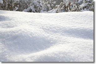
Weather Topic: What is Snow?
Home - Education - Precipitation - Snow
 Next Topic: Stratocumulus Clouds
Snow is precipitation taking the form of ice crystals. Each ice crystal, or snowflake,
has unique characteristics, but all of them grow in a hexagonal structure.
Snowfall can last for sustained periods of time and result in significant buildup
of snow on the ground.
On the earth's surface, snow starts out light and powdery, but as it begins to melt
it tends to become more granular, producing small bits of ice which have the consistency of
sand. After several cycles of melting and freezing, snow can become very dense
and ice-like, commonly known as snow pack.
Next Topic: Stratocumulus Clouds
Current conditions powered by WeatherAPI.com


