Weather Alert in California
Avalanche Watch issued February 15 at 7:10AM PST by NWS Reno NV
AREAS AFFECTED: Mono
DESCRIPTION: AVAREV The following message is transmitted at the request of the Eastern Sierra Avalanche Center. The Eastern Sierra Avalanche Center in Mammoth Lakes has issued a BACKCOUNTRY AVALANCHE WATCH for the following areas: NWS Las Vegas NV - CA-519 (Eastern Sierra in Inyo County) NWS Reno NV - CA-073 (Eastern Sierra in Mono County) * WHAT...The avalanche danger is expected to rise to HIGH by Monday afternoon (February 16) and remain elevated through mid- week. * WHERE...The eastern Sierra Nevada from Virginia Lakes to the southern end of Bishop Creek. * WHEN...In effect from Monday 7 AM PST to Tuesday 7 AM PST. * IMPACTS...Heavy snow and extreme winds will create widespread areas of unstable snow. * PRECAUTIONARY / PREPAREDNESS ACTIONS...Very dangerous avalanche conditions are expected to develop. Avalanches may run long distances, into mature forests, valley floors, or flat terrain. Travel in avalanche terrain is not recommended. Consult http://www.esavalanche.org/ or www.avalanche.org for more detailed information. Similar avalanche danger may exist at locations outside the coverage area of this or any avalanche center.
INSTRUCTION: N/A
Want more detail? Get the Complete 7 Day and Night Detailed Forecast!
Current U.S. National Radar--Current
The Current National Weather Radar is shown below with a UTC Time (subtract 5 hours from UTC to get Eastern Time).

National Weather Forecast--Current
The Current National Weather Forecast and National Weather Map are shown below.

National Weather Forecast for Tomorrow
Tomorrow National Weather Forecast and Tomorrow National Weather Map are show below.

North America Water Vapor (Moisture)
This map shows recent moisture content over North America. Bright and colored areas show high moisture (ie, clouds); brown indicates very little moisture present; black indicates no moisture.

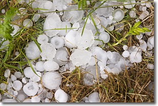
Weather Topic: What is Hail?
Home - Education - Precipitation - Hail
 Next Topic: Hole Punch Clouds
Hail is a form of precipitation which is recognized by large solid balls or
clumps of ice. Hail is created by thunderstorm clouds with strong updrafts of wind.
As the hailstones remain in the updraft, ice is deposited onto them until their
weight becomes heavy enough for them to fall to the earth's surface.
Hail storms can cause significant damage to crops, aircrafts, and man-made structures,
despite the fact that the duration is usually less than ten minutes.
Next Topic: Hole Punch Clouds
Weather Topic: What are Mammatus Clouds?
Home - Education - Cloud Types - Mammatus Clouds
 Next Topic: Nimbostratus Clouds
A mammatus cloud is a cloud with a unique feature which resembles
a web of pouches hanging along the base of the cloud.
In the United States, mammatus clouds tend to form in the warmer months, commonly
in the Midwest and eastern regions.
While they usually form at the bottom of a cumulonimbis cloud, they can also form
under altostratus, altocumulus, stratocumulus, and cirrus clouds. Mammatus clouds
warn that severe weather is close.
Next Topic: Nimbostratus Clouds
Current conditions powered by WeatherAPI.com


