Weather Alert in California
Flash Flood Warning issued February 16 at 1:52PM PST until February 16 at 4:00PM PST by NWS Los Angeles/Oxnard CA
AREAS AFFECTED: Los Angeles, CA
DESCRIPTION: FFWLOX The National Weather Service in Los Angeles/Oxnard has extended the * Flash Flood Warning for... Southwestern Los Angeles County in southwestern California... * Until 400 PM PST. * At 152 PM PST, Doppler radar and automated rain gauges indicated heavy rain falling across the warned area. Between 1.8 and 2.7 inches of rain have fallen. Flash flooding is ongoing or expected to begin shortly. Minor debris flows at the Palisades and Franklin Burn Scars. HAZARD...Flash flooding caused by heavy rain. Rock and mud slides. Minor debris flows at the Palisades and Franklin Burn Scars. SOURCE...Radar and automated gauges. IMPACT...Flash flooding of small creeks and streams, urban areas, highways, streets and underpasses as well as other poor drainage and low-lying areas. Rock and mud slides. Minor debris flows at the Palisades and Franklin Burn Scars. * Some locations that will experience flash flooding include... Thousand Oaks, Malibu, Woodland Hills, Encino, Santa Monica, Agoura Hills, Beverly Hills, North Hollywood, Hollywood, Universal City, Burbank, Griffith Park, Topanga State Park, Pacific Palisades, Calabasas, Brentwood, Malibu Creek State Park, Interstate 405 through the Sepulveda Pass and Bel Air. This also includes the Palisades and Franklin Burn Scars.
INSTRUCTION: Turn around, don't drown when encountering flooded roads. Most flood deaths occur in vehicles. Stay away or be swept away. River banks and culverts can become unstable and unsafe. Please report observed flooding to local emergency services or law enforcement and request they pass this information to the National Weather Service when you can do so safely.
Want more detail? Get the Complete 7 Day and Night Detailed Forecast!
Current U.S. National Radar--Current
The Current National Weather Radar is shown below with a UTC Time (subtract 5 hours from UTC to get Eastern Time).

National Weather Forecast--Current
The Current National Weather Forecast and National Weather Map are shown below.

National Weather Forecast for Tomorrow
Tomorrow National Weather Forecast and Tomorrow National Weather Map are show below.

North America Water Vapor (Moisture)
This map shows recent moisture content over North America. Bright and colored areas show high moisture (ie, clouds); brown indicates very little moisture present; black indicates no moisture.

Weather Topic: What is Sleet?
Home - Education - Precipitation - Sleet
 Next Topic: Snow
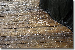
Sleet is a form of precipitation in which small ice pellets are the primary
components. These ice pellets are smaller and more translucent than hailstones,
and harder than graupel. Sleet is caused by specific atmospheric conditions and
therefore typically doesn't last for extended periods of time.
The condition which leads to sleet formation requires a warmer body of air to be
wedged in between two sub-freezing bodies of air. When snow falls through a warmer
layer of air it melts, and as it falls through the next sub-freezing body of air
it freezes again, forming ice pellets known as sleet. In some cases, water
droplets don't have time to freeze before reaching the surface and the result is
freezing rain.
Next Topic: Snow
Weather Topic: What are Stratocumulus Clouds?
Home - Education - Cloud Types - Stratocumulus Clouds
 Next Topic: Stratus Clouds
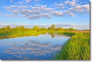
Stratocumulus clouds are similar to altocumulus clouds in their
fluffy appearance, but have a slightly darker shade due to their additional mass.
A good way to distinguish the two cloud types is to hold your hand out and measure
the size of an individual cloud; if it is the size of your thumb it is generally
an altocumulus cloud, if it is the size of your hand it is generally a
stratocumulus cloud.
It is uncommon for stratocumulus clouds to produce precipitation, but if they do
it is usually a light rain or snow.
Next Topic: Stratus Clouds
Current conditions powered by WeatherAPI.com


