Weather Alert in Montana
Winter Weather Advisory issued February 16 at 1:23PM MST until February 17 at 11:00PM MST by NWS Great Falls MT
AREAS AFFECTED: Hill County; Northern Blaine County
DESCRIPTION: * WHAT...Snow and blowing snow expected. Total snow accumulations between 1 and 3 inches. Winds gusting as high as 50 mph. * WHERE...Hill County and Northern Blaine County. * WHEN...From 11 AM to 11 PM MST Tuesday. * IMPACTS...Plan on slippery road conditions. Areas of blowing snow could significantly reduce visibility. * ADDITIONAL DETAILS...Rain and snow showers developing Tuesday afternoon will transition to a period of snow late Tuesday afternoon and evening. Gusty northwest winds and sharply falling temperatures are expected to develop Tuesday afternoon through Tuesday evening. While snowfall amounts are relatively low, the combination of gusty winds and blowing or drifting snow may also occur with previously wet road surfaces that become icy as temperatures fall.
INSTRUCTION: Slow down and use caution while traveling. The latest road conditions can be obtained by calling 5 1 1 or visiting the MDT Road Report website. To see a graphical representation of the degree of stress on young livestock please visit our webpage and select Local Programs then Cold Air Advisory for Newborn Livestock. Remember, a Winter Weather Advisory means that there is at least an 80% chance of minor impacts due to winter weather conditions during the advisory period.
Want more detail? Get the Complete 7 Day and Night Detailed Forecast!
Current U.S. National Radar--Current
The Current National Weather Radar is shown below with a UTC Time (subtract 5 hours from UTC to get Eastern Time).

National Weather Forecast--Current
The Current National Weather Forecast and National Weather Map are shown below.

National Weather Forecast for Tomorrow
Tomorrow National Weather Forecast and Tomorrow National Weather Map are show below.

North America Water Vapor (Moisture)
This map shows recent moisture content over North America. Bright and colored areas show high moisture (ie, clouds); brown indicates very little moisture present; black indicates no moisture.

Weather Topic: What is Snow?
Home - Education - Precipitation - Snow
 Next Topic: Stratocumulus Clouds
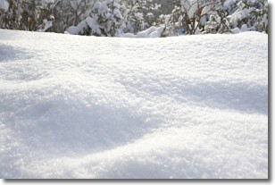
Snow is precipitation taking the form of ice crystals. Each ice crystal, or snowflake,
has unique characteristics, but all of them grow in a hexagonal structure.
Snowfall can last for sustained periods of time and result in significant buildup
of snow on the ground.
On the earth's surface, snow starts out light and powdery, but as it begins to melt
it tends to become more granular, producing small bits of ice which have the consistency of
sand. After several cycles of melting and freezing, snow can become very dense
and ice-like, commonly known as snow pack.
Next Topic: Stratocumulus Clouds
Weather Topic: What are Stratus Clouds?
Home - Education - Cloud Types - Stratus Clouds
 Next Topic: Wall Clouds
Stratus clouds are similar to altostratus clouds, but form at a
lower altitude and are identified by their fog-like appearance, lacking the
distinguishing features of most clouds.
Stratus clouds are wider than most clouds, and their base has a smooth, uniform
look which is lighter in color than a nimbostratus cloud.
The presence of a stratus cloud indicates the possibility of minor precipitation,
such as drizzle, but heavier precipitation does not typically arrive in the form
of a stratus cloud.
Next Topic: Wall Clouds
Current conditions powered by WeatherAPI.com


