Weather Alert in Montana
Avalanche Warning issued March 12 at 7:54AM MDT by NWS Missoula MT
AREAS AFFECTED: Kootenai/Cabinet Region
DESCRIPTION: AVWMSO The following message is transmitted at the request of Idaho Panhandle Avalanche Center Sandpoint ID. ...AVALANCHE WARNING ISSUED BY THE IDAHO PANHANDLE AVALANCHE CENTER... 07:00 PDT Thu Mar 12 2026 The Idaho Panhandle Avalanche Center in Sandpoint has issued a BACKCOUNTRY AVALANCHE WARNING for the following areas: NWS Missoula MT - MTZ001 (MTZ001) NWS Spokane WA - ID 017 (Bonner County)...ID 021 (Boundary County)...ID 079 (Shoshone County) * WHAT...An Avalanche Warning is in effect from Thursday 7 AM PST to Friday 7 AM PST. Very dangerous avalanche conditions have developed from heavy snowfall and strong to extreme winds and will last through Friday. You can very easily trigger avalanches large enough to bury or kill you, and some will release spontaneously. Avoid travel in avalanche terrain during this period. * WHERE...The West Cabinet Mountains, the East Cabinet Mountains, and the Bitterroot Mountains - Silver Valley above 4,000 feet. * WHEN...In effect from Thu 07:00 PDT to Fri 07:00 PDT. * IMPACTS...An atmospheric river and violent jet stream have joined forces to deliver heavy snowfall and strong to extreme winds. Snowfall is being measured in multiple feet at higher elevations, and the new snow has formed dangerous slabs of snow and will likely cause a widespread cycle of natural avalanches large enough to bury, injure, or kill a person. It will be very easy for backcountry travelers to trigger them during this period. * PRECAUTIONARY / PREPAREDNESS ACTIONS...Travel in and around avalanche terrain is not recommended during this period. Consult http://www.idahopanhandleavalanche.org/ or www.avalanche.org for more detailed information. Similar avalanche danger may exist at locations outside the coverage area of this or any avalanche center.
INSTRUCTION: N/A
Want more detail? Get the Complete 7 Day and Night Detailed Forecast!
Current U.S. National Radar--Current
The Current National Weather Radar is shown below with a UTC Time (subtract 5 hours from UTC to get Eastern Time).

National Weather Forecast--Current
The Current National Weather Forecast and National Weather Map are shown below.

National Weather Forecast for Tomorrow
Tomorrow National Weather Forecast and Tomorrow National Weather Map are show below.

North America Water Vapor (Moisture)
This map shows recent moisture content over North America. Bright and colored areas show high moisture (ie, clouds); brown indicates very little moisture present; black indicates no moisture.

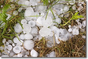
Weather Topic: What is Hail?
Home - Education - Precipitation - Hail
 Next Topic: Hole Punch Clouds
Hail is a form of precipitation which is recognized by large solid balls or
clumps of ice. Hail is created by thunderstorm clouds with strong updrafts of wind.
As the hailstones remain in the updraft, ice is deposited onto them until their
weight becomes heavy enough for them to fall to the earth's surface.
Hail storms can cause significant damage to crops, aircrafts, and man-made structures,
despite the fact that the duration is usually less than ten minutes.
Next Topic: Hole Punch Clouds
Weather Topic: What are Mammatus Clouds?
Home - Education - Cloud Types - Mammatus Clouds
 Next Topic: Nimbostratus Clouds
A mammatus cloud is a cloud with a unique feature which resembles
a web of pouches hanging along the base of the cloud.
In the United States, mammatus clouds tend to form in the warmer months, commonly
in the Midwest and eastern regions.
While they usually form at the bottom of a cumulonimbis cloud, they can also form
under altostratus, altocumulus, stratocumulus, and cirrus clouds. Mammatus clouds
warn that severe weather is close.
Next Topic: Nimbostratus Clouds
Current conditions powered by WeatherAPI.com


