Weather Alert in California
Extreme Cold Warning issued February 18 at 11:25PM PST until February 20 at 9:00AM PST by NWS San Francisco CA
AREAS AFFECTED: North Bay Interior Mountains; North Bay Interior Valleys; East Bay Interior Valleys; Eastern Santa Clara Hills; East Bay Hills; Southern Salinas Valley/Arroyo Seco and Lake San Antonio; Santa Lucia Mountains and Los Padres National Forest; Mountains Of San Benito County And Interior Monterey County Including Pinnacles National Park
DESCRIPTION: * WHAT...Very cold conditions with sub-freezing temperatures in the mid-20s to low-30s expected. * WHERE...The East Bay Hills and Valleys, Interior Monterey County and the Santa Lucia Range, Most of San Benito County and the Cholame Hills in Southeast Monterey County, North Bay Interior Mountains, North Bay Interior Valleys, Eastern Santa Clara Hills, and Southern Salinas Valley/Arroyo Seco and Lake San Antonio. * WHEN...From 1 AM to 9 AM PST Friday. * IMPACTS...Cold conditions will be hazardous to sensitive populations such as unhoused individuals. Cold conditions may damage or kill sensitive crops, plants, and vegetation if appropriate precautions are not taken. Prolonged exposure to the cold conditions will lead to hypothermia for people, pets, and livestock.
INSTRUCTION: Ensure portable heaters are working properly and are used correctly to avoid sparking a fire indoors. Do not use generators or grills inside as carbon monoxide poisoning can result. Check with your local, city, or county officials for information on available warming centers. Be sure to dress in layers if outdoors. Make sure that pets and livestock have adequate food, unfrozen water, and warmth. Cover or tend to sensitive crops, plants, and vegetation.
Want more detail? Get the Complete 7 Day and Night Detailed Forecast!
Current U.S. National Radar--Current
The Current National Weather Radar is shown below with a UTC Time (subtract 5 hours from UTC to get Eastern Time).

National Weather Forecast--Current
The Current National Weather Forecast and National Weather Map are shown below.

National Weather Forecast for Tomorrow
Tomorrow National Weather Forecast and Tomorrow National Weather Map are show below.

North America Water Vapor (Moisture)
This map shows recent moisture content over North America. Bright and colored areas show high moisture (ie, clouds); brown indicates very little moisture present; black indicates no moisture.

Weather Topic: What is Snow?
Home - Education - Precipitation - Snow
 Next Topic: Stratocumulus Clouds
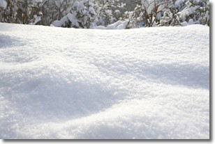
Snow is precipitation taking the form of ice crystals. Each ice crystal, or snowflake,
has unique characteristics, but all of them grow in a hexagonal structure.
Snowfall can last for sustained periods of time and result in significant buildup
of snow on the ground.
On the earth's surface, snow starts out light and powdery, but as it begins to melt
it tends to become more granular, producing small bits of ice which have the consistency of
sand. After several cycles of melting and freezing, snow can become very dense
and ice-like, commonly known as snow pack.
Next Topic: Stratocumulus Clouds
Weather Topic: What are Stratus Clouds?
Home - Education - Cloud Types - Stratus Clouds
 Next Topic: Wall Clouds
Stratus clouds are similar to altostratus clouds, but form at a
lower altitude and are identified by their fog-like appearance, lacking the
distinguishing features of most clouds.
Stratus clouds are wider than most clouds, and their base has a smooth, uniform
look which is lighter in color than a nimbostratus cloud.
The presence of a stratus cloud indicates the possibility of minor precipitation,
such as drizzle, but heavier precipitation does not typically arrive in the form
of a stratus cloud.
Next Topic: Wall Clouds
Current conditions powered by WeatherAPI.com


