Weather Alert in California
Winter Storm Warning issued February 16 at 1:01PM PST until February 19 at 10:00PM PST by NWS Sacramento CA
AREAS AFFECTED: Northern Sacramento Valley
DESCRIPTION: * WHAT...Low elevation snow. Light snow accumulations up to one inch. Winds gusting as high as 40 mph. * WHERE...Northern Sacramento Valley, including the city of Redding. * WHEN...Until 10 PM PST Thursday. * IMPACTS...The hazardous conditions could impact morning commutes through Thursday. * ADDITIONAL DETAILS...Snow levels will be around 2500 to 3500 feet by Monday night and 1500 to 2500 feet Tuesday through Thursday. Potential for snow levels below 1000 feet in the northern Sacramento Valley. Lowest snow levels and highest potential for low elevation snowfall on Wednesday and Thursday mornings.
INSTRUCTION: Check the latest road conditions from Caltrans online at quickmap.dot.ca.gov or dial 5 1 1.
Want more detail? Get the Complete 7 Day and Night Detailed Forecast!
Current U.S. National Radar--Current
The Current National Weather Radar is shown below with a UTC Time (subtract 5 hours from UTC to get Eastern Time).

National Weather Forecast--Current
The Current National Weather Forecast and National Weather Map are shown below.

National Weather Forecast for Tomorrow
Tomorrow National Weather Forecast and Tomorrow National Weather Map are show below.

North America Water Vapor (Moisture)
This map shows recent moisture content over North America. Bright and colored areas show high moisture (ie, clouds); brown indicates very little moisture present; black indicates no moisture.

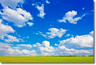
Weather Topic: What are Cumulus Clouds?
Home - Education - Cloud Types - Cumulus Clouds
 Next Topic: Drizzle
Cumulus clouds are fluffy and textured with rounded tops, and
may have flat bottoms. The border of a cumulus cloud
is clearly defined, and can have the appearance of cotton or cauliflower.
Cumulus clouds form at low altitudes (rarely above 2 km) but can grow very tall,
becoming cumulus congestus and possibly the even taller cumulonimbus clouds.
When cumulus clouds become taller, they have a greater chance of producing precipitation.
Next Topic: Drizzle
Weather Topic: What is Evaporation?
Home - Education - Precipitation - Evaporation
 Next Topic: Fog
Evaporation is the process which returns water from the earth
back to the atmosphere, and is another crucial process in the water cycle.
Evaporation is the transformation of liquid into gas, and it happens because
molecules are excited by the application of energy and turn into vapor.
In order for water to evaporate it has to be on the surface of a body of water.
Next Topic: Fog
Current conditions powered by WeatherAPI.com


