Weather Alert in New Mexico
Fire Weather Watch issued March 13 at 1:23PM MDT until March 15 at 6:00PM MDT by NWS El Paso Tx/Santa Teresa NM
AREAS AFFECTED: South Central Lowlands And Southern Rio Grande Valley; El Paso; Hudspeth
DESCRIPTION: ...CRITICAL FIRE CONDITIONS SATURDAY AND SUNDAY ACROSS SOUTHWEST, SOUTH CENTRAL NEW MEXICO AND FAR WEST TEXAS... High pressure nudging in from the west is causing temperatures to be well above seasonal averages, and relative humidity to be critically low. Daily highs this weekend will average over 10 degrees above normal, as relative humidity drops into the low teens and single-digits both days, with very poor overnight recovery. A two-day trough passage to our north will add increased winds mid afternoon on Saturday, which will continue and further strengthen overnight into Sunday. These winds combined with single digit RH's, warm temperatures, and drying fuels will lead to critical fire weather conditions. * AFFECTED AREA...Texas Fire Weather Zones 055 and 056 in El Paso and Hudspeth Counties. Fire Weather Zone 112 South Central Lowlands and Southern Rio Grande Valley areas. * TIMING...Noon to 6 PM Sunday. * WINDS...Northwest 20 to 30 mph with gusts up to 45 mph. * RELATIVE HUMIDITY...As low as 7 percent. * TEMPERATURES...Up to 84. * WIND... Northwest winds 20-25 mph with gusts to 40 MPH * HUMIDITY...7 to 11 percent * EXPERIMENTAL RFTI... 4 to 5 Marginally critical to critical * IMPACTS...any fires that develop will likely spread rapidly. Outdoor burning is not recommended.
INSTRUCTION: A Fire Weather Watch means that critical fire weather conditions are forecast to occur. Listen for later forecasts and possible Red Flag Warnings.
Want more detail? Get the Complete 7 Day and Night Detailed Forecast!
Current U.S. National Radar--Current
The Current National Weather Radar is shown below with a UTC Time (subtract 5 hours from UTC to get Eastern Time).

National Weather Forecast--Current
The Current National Weather Forecast and National Weather Map are shown below.

National Weather Forecast for Tomorrow
Tomorrow National Weather Forecast and Tomorrow National Weather Map are show below.

North America Water Vapor (Moisture)
This map shows recent moisture content over North America. Bright and colored areas show high moisture (ie, clouds); brown indicates very little moisture present; black indicates no moisture.

Weather Topic: What are Contrails?
Home - Education - Cloud Types - Contrails
 Next Topic: Cumulonimbus Clouds
A contrail is an artificial cloud, created by the passing of an
aircraft.
Contrails form because water vapor in the exhaust of aircraft engines is suspended
in the air under certain temperatures and humidity conditions. These contrails
are called exhaust contrails.
Another type of contrail can form due to a temporary reduction in air pressure
moving over the plane's surface, causing condensation.
These are called aerodynamic contrails.
When you can see your breath on a cold day, it is also because of condensation.
The reason contrails last longer than the condensation from your breath is
because the water in contrails freezes into ice particles.
Next Topic: Cumulonimbus Clouds
Weather Topic: What are Cumulus Clouds?
Home - Education - Cloud Types - Cumulus Clouds
 Next Topic: Drizzle
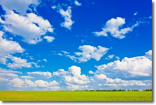
Cumulus clouds are fluffy and textured with rounded tops, and
may have flat bottoms. The border of a cumulus cloud
is clearly defined, and can have the appearance of cotton or cauliflower.
Cumulus clouds form at low altitudes (rarely above 2 km) but can grow very tall,
becoming cumulus congestus and possibly the even taller cumulonimbus clouds.
When cumulus clouds become taller, they have a greater chance of producing precipitation.
Next Topic: Drizzle
Current conditions powered by WeatherAPI.com


