Weather Alert in California
Avalanche Watch issued February 15 at 7:36AM PST by NWS Las Vegas NV
AREAS AFFECTED: Eastern Sierra Slopes of Inyo County
DESCRIPTION: AVAVEF The Eastern Sierra Avalanche Center in Mammoth Lakes has issued a Backcountry Avalanche Watch for the following areas: the Eastern Sierra in Mono County and the Eastern Sierra in Inyo County * WHAT...The avalanche danger is expected to rise to HIGH by tomorrow afternoon and remain elevated into mid-week. * WHERE...The eastern slopes of the Sierra Nevada mountain range between Virgina Lakes on the north to Bishop Creek on the south. * WHEN...In effect from Sun 07:00 PST to Mon 07:00 PST. * IMPACTS...|Heavy snow and extreme winds will create widespread areas of unstable snow.
INSTRUCTION: Very dangerous avalanche conditions are expected to develop. Avalanches may run long distances, and can run into mature forests, valley floors or flat terrain. Travel in avalanche terrain is not recommended. Consult http://www.esavalanche.org or www.avalanche.org for more detailed information Similar avalanche danger may exist at locations outside the coverage area of this or any avalanche center.
Want more detail? Get the Complete 7 Day and Night Detailed Forecast!
Current U.S. National Radar--Current
The Current National Weather Radar is shown below with a UTC Time (subtract 5 hours from UTC to get Eastern Time).

National Weather Forecast--Current
The Current National Weather Forecast and National Weather Map are shown below.

National Weather Forecast for Tomorrow
Tomorrow National Weather Forecast and Tomorrow National Weather Map are show below.

North America Water Vapor (Moisture)
This map shows recent moisture content over North America. Bright and colored areas show high moisture (ie, clouds); brown indicates very little moisture present; black indicates no moisture.

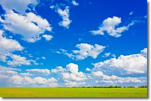
Weather Topic: What are Cumulus Clouds?
Home - Education - Cloud Types - Cumulus Clouds
 Next Topic: Drizzle
Cumulus clouds are fluffy and textured with rounded tops, and
may have flat bottoms. The border of a cumulus cloud
is clearly defined, and can have the appearance of cotton or cauliflower.
Cumulus clouds form at low altitudes (rarely above 2 km) but can grow very tall,
becoming cumulus congestus and possibly the even taller cumulonimbus clouds.
When cumulus clouds become taller, they have a greater chance of producing precipitation.
Next Topic: Drizzle
Weather Topic: What is Evaporation?
Home - Education - Precipitation - Evaporation
 Next Topic: Fog
Evaporation is the process which returns water from the earth
back to the atmosphere, and is another crucial process in the water cycle.
Evaporation is the transformation of liquid into gas, and it happens because
molecules are excited by the application of energy and turn into vapor.
In order for water to evaporate it has to be on the surface of a body of water.
Next Topic: Fog
Current conditions powered by WeatherAPI.com


