Weather Alert in Montana
Winter Storm Warning issued March 11 at 9:21AM MDT until March 14 at 12:00PM MDT by NWS Missoula MT
AREAS AFFECTED: Bitterroot/Sapphire Mountains
DESCRIPTION: * WHAT...Heavy snow expected above 5000 feet. There is a likelihood of major winter weather impacts to isolated extreme winter storm impacts. Total snow accumulations between 3 to 8 inches in the lower elevations, with 2 to 5 feet above 5,000 feet. Wind gusts between 50 to 70 mph, with gusts of 80 mph or greater along the Bitterroot Crest. * WHERE...Highway 93 Sula to Lost Trail Pass and Lolo Pass. * WHEN...From 6 PM this evening to noon MDT Saturday. * IMPACTS...For EXTREME winter storm impacts, expect substantial disruptions to normal activities. Extremely dangerous or impossible traveling conditions. Travel in the impacted areas is not advised. Extensive and widespread closures and disruptions to infrastructure may occur. Life saving actions may be needed. The hazardous conditions could impact the Thursday morning and evening commutes, especially over higher passes. * ADDITIONAL DETAILS...Strong and potentially damaging winds will impact all elevations Thursday morning. Periods of blizzard conditions will impact Lost Trail Pass and the higher elevations Thursday morning.
INSTRUCTION: Persons should delay all travel if possible. If travel is absolutely necessary, drive with extreme caution and be prepared for sudden changes in visibility. Leave plenty of room between you and the motorist ahead of you, and allow extra time to reach your destination. Avoid sudden braking or acceleration, and be especially cautious on hills or when making turns. Make sure your car is winterized and in good working order. Do not touch downed lines and report any power outages to your electric company. Travel is highly discouraged due to slick roadways and the possibility of downed trees and power lines.
Want more detail? Get the Complete 7 Day and Night Detailed Forecast!
Current U.S. National Radar--Current
The Current National Weather Radar is shown below with a UTC Time (subtract 5 hours from UTC to get Eastern Time).

National Weather Forecast--Current
The Current National Weather Forecast and National Weather Map are shown below.

National Weather Forecast for Tomorrow
Tomorrow National Weather Forecast and Tomorrow National Weather Map are show below.

North America Water Vapor (Moisture)
This map shows recent moisture content over North America. Bright and colored areas show high moisture (ie, clouds); brown indicates very little moisture present; black indicates no moisture.

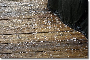
Weather Topic: What is Sleet?
Home - Education - Precipitation - Sleet
 Next Topic: Snow
Sleet is a form of precipitation in which small ice pellets are the primary
components. These ice pellets are smaller and more translucent than hailstones,
and harder than graupel. Sleet is caused by specific atmospheric conditions and
therefore typically doesn't last for extended periods of time.
The condition which leads to sleet formation requires a warmer body of air to be
wedged in between two sub-freezing bodies of air. When snow falls through a warmer
layer of air it melts, and as it falls through the next sub-freezing body of air
it freezes again, forming ice pellets known as sleet. In some cases, water
droplets don't have time to freeze before reaching the surface and the result is
freezing rain.
Next Topic: Snow
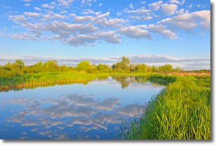
Weather Topic: What are Stratocumulus Clouds?
Home - Education - Cloud Types - Stratocumulus Clouds
 Next Topic: Stratus Clouds
Stratocumulus clouds are similar to altocumulus clouds in their
fluffy appearance, but have a slightly darker shade due to their additional mass.
A good way to distinguish the two cloud types is to hold your hand out and measure
the size of an individual cloud; if it is the size of your thumb it is generally
an altocumulus cloud, if it is the size of your hand it is generally a
stratocumulus cloud.
It is uncommon for stratocumulus clouds to produce precipitation, but if they do
it is usually a light rain or snow.
Next Topic: Stratus Clouds
Current conditions powered by WeatherAPI.com


