Weather Alert in Missouri
Flood Warning issued July 21 at 8:09PM CDT until July 24 at 11:40AM CDT by NWS St Louis MO
AREAS AFFECTED: Lincoln, MO
DESCRIPTION: ...The Flood Warning continues for the following rivers in Missouri... Cuivre River near Troy. ...The Flood Warning is extended for the following rivers in Missouri... Mid Fork Salt River near Holliday. Cuivre River at Old Monroe. North Fabius River near Ewing. River forecasts are based on observed precipitation and forecast precipitation for the next 24 hours. * WHAT...Moderate flooding is occurring and moderate flooding is forecast. * WHERE...Cuivre River near Troy. * WHEN...Until Thursday morning. * IMPACTS...At 28.0 feet, Near this height, MoDoT will consider closing U.S. Highway 61 at the Cuivre River bridge north of Troy in both directions. * ADDITIONAL DETAILS... - At 8:00 PM CDT Monday the stage was 25.1 feet. - Recent Activity...The maximum river stage in the 24 hours ending at 8:00 PM CDT Monday was 25.1 feet. - Forecast...The river is expected to rise to a crest of 27.9 feet early tomorrow afternoon. It will then fall below flood stage early Wednesday morning. - Flood stage is 21.0 feet.
INSTRUCTION: Turn around, don't drown when encountering flooded roads. Most flood deaths occur in vehicles. Motorists should not attempt to drive around barricades or drive cars through flooded areas. This product, along with additional weather and stream information, is available at https://water.noaa.gov/wfo/lsx
Want more detail? Get the Complete 7 Day and Night Detailed Forecast!
Current U.S. National Radar--Current
The Current National Weather Radar is shown below with a UTC Time (subtract 5 hours from UTC to get Eastern Time).

National Weather Forecast--Current
The Current National Weather Forecast and National Weather Map are shown below.

National Weather Forecast for Tomorrow
Tomorrow National Weather Forecast and Tomorrow National Weather Map are show below.

North America Water Vapor (Moisture)
This map shows recent moisture content over North America. Bright and colored areas show high moisture (ie, clouds); brown indicates very little moisture present; black indicates no moisture.

Weather Topic: What is Freezing Rain?
Home - Education - Precipitation - Freezing Rain
 Next Topic: Graupel
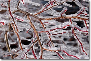
Freezing rain is a condition where precipitation which has fallen in the form of
water droplets reaches temperatures which are below freezing and freezes upon
coming into contact
with surface objects. The result of this precipitation is a glaze of ice which
can be damaging to plants and man-made structures. A severe onset of freezing
rain which results in a very thick glaze of ice is known as an ice storm.
Next Topic: Graupel
Weather Topic: What is Hail?
Home - Education - Precipitation - Hail
 Next Topic: Hole Punch Clouds
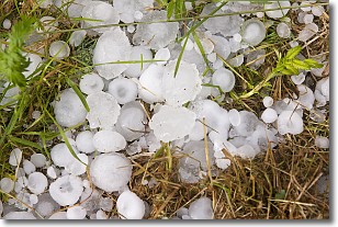
Hail is a form of precipitation which is recognized by large solid balls or
clumps of ice. Hail is created by thunderstorm clouds with strong updrafts of wind.
As the hailstones remain in the updraft, ice is deposited onto them until their
weight becomes heavy enough for them to fall to the earth's surface.
Hail storms can cause significant damage to crops, aircrafts, and man-made structures,
despite the fact that the duration is usually less than ten minutes.
Next Topic: Hole Punch Clouds
Current conditions powered by WeatherAPI.com


