Weather Alert in Alaska
Winter Weather Advisory issued February 19 at 10:59AM AKST until February 20 at 6:00AM AKST by NWS Juneau AK
AREAS AFFECTED: Petersburg Borough; Western Kupreanof and Kuiu Island; City and Borough of Wrangell
DESCRIPTION: ...ACCUMULATING SNOW ACROSS THE PANHANDLE TO END THE WEEK... .A front moving across the gulf has begun to impact the panhandle with snow showers spreading along the outer coast and reaching southward to Petersburg and Wrangell as of 1045 am Thursday. The highest snow accumulations are still expected along the outer coast with orographic enhancement. A secondary batch of heavier showers will develop along the northern panhandle and progress southward as a deformation band associated with the surface low Thursday night into Friday. For inland areas, snow is expected to be light and fluffy in nature due to cold temperatures both aloft and down to the surface. Coastal communities will likely see wetter snow due to slightly warming surface temperatures through the day. * WHAT...Snow expected. Total snow accumulations of 3 to 6 inches. * WHERE...Petersburg Borough, Western Kupreanof Island and Kuiu Island and City and Borough of Wrangell. * WHEN...Until 6 AM AKST Friday. * IMPACTS...Travel could be very difficult. * ADDITIONAL DETAILS...Light snow showers have begun to impact the area. These showers will pick up in intensity through the day Thursday as the frontal band continues pushing inland. A secondary batch of heavier showers remains possible as the surface low drops southward in the gulf Friday.
INSTRUCTION: Slow down and use caution while traveling. People are urged to prepare their property before the onset of winter weather. For the latest road conditions, where available, call 5 1 1 or visit 511.alaska.gov.
Want more detail? Get the Complete 7 Day and Night Detailed Forecast!
Current U.S. National Radar--Current
The Current National Weather Radar is shown below with a UTC Time (subtract 5 hours from UTC to get Eastern Time).

National Weather Forecast--Current
The Current National Weather Forecast and National Weather Map are shown below.

National Weather Forecast for Tomorrow
Tomorrow National Weather Forecast and Tomorrow National Weather Map are show below.

North America Water Vapor (Moisture)
This map shows recent moisture content over North America. Bright and colored areas show high moisture (ie, clouds); brown indicates very little moisture present; black indicates no moisture.

Weather Topic: What is Rain?
Home - Education - Precipitation - Rain
 Next Topic: Shelf Clouds
Precipitation in the form of water droplets is called rain.
Rain generally has a tendency to fall with less intensity over a greater period
of time, and when rainfall is more severe it is usually less sustained.
Rain is the most common form of precipitation and happens with greater frequency
depending on the season and regional influences. Cities have been shown to have
an observable effect on rainfall, due to an effect called the urban heat island.
Compared to upwind, monthly rainfall between twenty and forty miles downwind of
cities is 30% greater.
Next Topic: Shelf Clouds
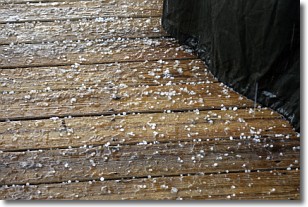
Weather Topic: What is Sleet?
Home - Education - Precipitation - Sleet
 Next Topic: Snow
Sleet is a form of precipitation in which small ice pellets are the primary
components. These ice pellets are smaller and more translucent than hailstones,
and harder than graupel. Sleet is caused by specific atmospheric conditions and
therefore typically doesn't last for extended periods of time.
The condition which leads to sleet formation requires a warmer body of air to be
wedged in between two sub-freezing bodies of air. When snow falls through a warmer
layer of air it melts, and as it falls through the next sub-freezing body of air
it freezes again, forming ice pellets known as sleet. In some cases, water
droplets don't have time to freeze before reaching the surface and the result is
freezing rain.
Next Topic: Snow
Current conditions powered by WeatherAPI.com


