Weather Alert in South Carolina
Flood Advisory issued September 6 at 6:06PM EDT until September 6 at 8:00PM EDT by NWS Columbia SC
AREAS AFFECTED: Kershaw, SC; Lexington, SC; Richland, SC
DESCRIPTION: * WHAT...Flooding caused by excessive rainfall is expected. * WHERE...A portion of central South Carolina, including the following counties, Kershaw, Lexington and Richland. * WHEN...Until 800 PM EDT. * IMPACTS...Minor flooding in low-lying and poor drainage areas. Some low-water crossings may become impassable. Ponding of water in urban or other areas is occurring or is imminent. * ADDITIONAL DETAILS... - At 603 PM EDT, Doppler radar indicated heavy rain due to thunderstorms. Minor flooding is ongoing or expected to begin shortly in the advisory area. Between 1 and 1.5 inches of rain have fallen over the St. Andrews area and near Riverbanks Zoo and West Columbia into the Forest Acres area. - Additional rainfall amounts of 1 to 1.5 inches are possible over the area. This additional rain will result in minor flooding. - Some locations that will experience flooding include... Columbia, West Columbia, Cayce, Forest Acres, Springdale, Dentsville, St. Andrews, Oak Grove, Elgin, Arcadia Lakes, Woodfield, Sesquicentennial State Park, Killian, Five Points, Villages at Sandhill, Columbia International University, SC State Fair Grounds, West Columbia Riverwalk, Lake Carolina and Riverbanks Zoo. - This includes the following highways... Interstate 126 between mile markers 0 and 3. Interstate 26 between mile markers 106 and 113. Interstate 20 in South Carolina between mile markers 62 and 80. Interstate 77 between mile markers 11 and 23. - http://www.weather.gov/safety/flood
INSTRUCTION: Most flooding deaths occur in vehicles. Never drive through a flooded roadway or around barricades. Turn around, don't drown. Be aware of your surroundings and do not drive on flooded roads.
Want more detail? Get the Complete 7 Day and Night Detailed Forecast!
Current U.S. National Radar--Current
The Current National Weather Radar is shown below with a UTC Time (subtract 5 hours from UTC to get Eastern Time).

National Weather Forecast--Current
The Current National Weather Forecast and National Weather Map are shown below.

National Weather Forecast for Tomorrow
Tomorrow National Weather Forecast and Tomorrow National Weather Map are show below.

North America Water Vapor (Moisture)
This map shows recent moisture content over North America. Bright and colored areas show high moisture (ie, clouds); brown indicates very little moisture present; black indicates no moisture.

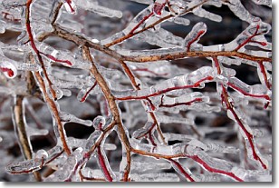
Weather Topic: What is Freezing Rain?
Home - Education - Precipitation - Freezing Rain
 Next Topic: Graupel
Freezing rain is a condition where precipitation which has fallen in the form of
water droplets reaches temperatures which are below freezing and freezes upon
coming into contact
with surface objects. The result of this precipitation is a glaze of ice which
can be damaging to plants and man-made structures. A severe onset of freezing
rain which results in a very thick glaze of ice is known as an ice storm.
Next Topic: Graupel
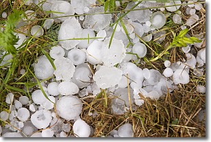
Weather Topic: What is Hail?
Home - Education - Precipitation - Hail
 Next Topic: Hole Punch Clouds
Hail is a form of precipitation which is recognized by large solid balls or
clumps of ice. Hail is created by thunderstorm clouds with strong updrafts of wind.
As the hailstones remain in the updraft, ice is deposited onto them until their
weight becomes heavy enough for them to fall to the earth's surface.
Hail storms can cause significant damage to crops, aircrafts, and man-made structures,
despite the fact that the duration is usually less than ten minutes.
Next Topic: Hole Punch Clouds
Current conditions powered by WeatherAPI.com


