Weather Alert in New York
Winter Storm Warning issued February 20 at 1:28PM EST until February 21 at 10:00AM EST by NWS Burlington VT
AREAS AFFECTED: Northern St. Lawrence; Eastern Clinton; Southern Franklin; Western Clinton; Western Essex; Eastern Essex; Grand Isle; Washington; Orange; Eastern Addison; Eastern Rutland; Western Windsor; Eastern Windsor
DESCRIPTION: * WHAT...Heavy snow. Total snow accumulations between 5 and 10 inches. * WHERE...Portions of northern New York and central, northwest, and southern Vermont. * WHEN...Until 10 AM EST Saturday. * IMPACTS...Travel could be very difficult. The hazardous conditions will impact this evening's commute. * ADDITIONAL DETAILS...Snowfall rates of 1 to 2 inches per hour are likely, especially between 4 and 8 PM. Snow will be initially wet and become increasingly dry tonight into Saturday. Isolated power outages could occur due to the weight of the snow.
INSTRUCTION: If you must travel, keep an extra flashlight, food, and water in your vehicle in case of an emergency. For the latest on road conditions in Vermont, visit https://newengland511.org and for New York, visit https://511ny.org.
Want more detail? Get the Complete 7 Day and Night Detailed Forecast!
Current U.S. National Radar--Current
The Current National Weather Radar is shown below with a UTC Time (subtract 5 hours from UTC to get Eastern Time).

National Weather Forecast--Current
The Current National Weather Forecast and National Weather Map are shown below.

National Weather Forecast for Tomorrow
Tomorrow National Weather Forecast and Tomorrow National Weather Map are show below.

North America Water Vapor (Moisture)
This map shows recent moisture content over North America. Bright and colored areas show high moisture (ie, clouds); brown indicates very little moisture present; black indicates no moisture.

Weather Topic: What are Fractus Clouds?
Home - Education - Cloud Types - Fractus Clouds
 Next Topic: Freezing Rain
A fractus cloud (scud) is a fragmented, tattered cloud which has
likely been sheared off of another cloud. They are accessory clouds, meaning they
develop from parent clouds, and are named in a way which describes the original
cloud which contained them.
Fractus clouds which have originated from cumulus clouds are referred to as
cumulus fractus, while fractus clouds which have originated from stratus clouds
are referred to as stratus fractus. Under certain conditions a fractus cloud might
merge with another cloud, or develop into a cumulus cloud, but usually a
fractus cloud seen by itself will dissipate rapidly.
They are often observed on the leading and trailing edges of storm clouds,
and are a display of wind activity.
Next Topic: Freezing Rain
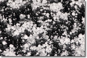
Weather Topic: What is Graupel?
Home - Education - Precipitation - Graupel
 Next Topic: Hail
Graupel is a form of precipitation that is created by atmospheric conditions
which cause supercooled water droplets to contact snow crystals and freeze to
their surface.
Sometimes known as soft hail or snow pellets, graupel is delicate and easily
destroyed by touch. Whereas hail usually falls during severe weather, graupel
doesn't require such conditions to form, and can form in mild precipitation
similar to situations which produce snowfall.
Next Topic: Hail
Current conditions powered by WeatherAPI.com


