Weather Alert in South Dakota
High Wind Warning issued March 12 at 5:53AM MDT until March 12 at 9:00PM MDT by NWS Rapid City SD
AREAS AFFECTED: Harding; Northern Perkins; Butte; Northern Meade Co Plains; Ziebach; Northern Foothills; Rapid City; Southern Foothills; Custer Co Plains; Pennington Co Plains; Haakon; Western Fall River; Northern Oglala Lakota; Northern Jackson; Bennett; Mellette; Todd; Tripp; Sturgis/Piedmont Foothills; Southern Meade Co Plains; Hermosa Foothills; Eastern Fall River; Southern Oglala Lakota; Southern Jackson; Southern Perkins; Northeastern Crook
DESCRIPTION: * WHAT...West winds 35 to 55 mph with gusts up to 80 mph expected. * WHERE...Portions of northwestern, south central, and southwestern South Dakota and northeast Wyoming. * WHEN...From 9 AM MDT /10 AM CDT/ this morning to 9 PM MDT /10 PM CDT/ this evening. * IMPACTS...The high winds may damage roofs, small outbuildings, and signs. Power outages are possible. Travel could be difficult, especially for high profile vehicles. Strong winds can cause blowing dust, reduced visibility, and flying debris.
INSTRUCTION: A high wind warning means 40 mph winds, or gusts over 60 mph, are expected or occurring. If you are outdoors, watch for flying or falling objects that may injure you. Use caution if you must drive.
Want more detail? Get the Complete 7 Day and Night Detailed Forecast!
Current U.S. National Radar--Current
The Current National Weather Radar is shown below with a UTC Time (subtract 5 hours from UTC to get Eastern Time).

National Weather Forecast--Current
The Current National Weather Forecast and National Weather Map are shown below.

National Weather Forecast for Tomorrow
Tomorrow National Weather Forecast and Tomorrow National Weather Map are show below.

North America Water Vapor (Moisture)
This map shows recent moisture content over North America. Bright and colored areas show high moisture (ie, clouds); brown indicates very little moisture present; black indicates no moisture.

Weather Topic: What are Shelf Clouds?
Home - Education - Cloud Types - Shelf Clouds
 Next Topic: Sleet
A shelf cloud is similar to a wall cloud, but forms at the front
of a storm cloud, instead of at the rear, where wall clouds form.
A shelf cloud is caused by a series of events set into motion by the advancing
storm; first, cool air settles along the ground where precipitation has just fallen.
As the cool air is brought in, the warmer air is displaced, and rises above it,
because it is less dense. When the warmer air reaches the bottom of the storm cloud,
it begins to cool again, and the resulting condensation is a visible shelf cloud.
Next Topic: Sleet
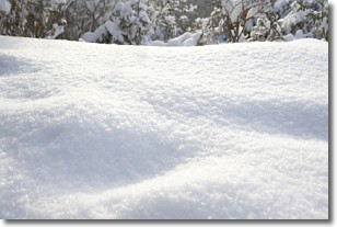
Weather Topic: What is Snow?
Home - Education - Precipitation - Snow
 Next Topic: Stratocumulus Clouds
Snow is precipitation taking the form of ice crystals. Each ice crystal, or snowflake,
has unique characteristics, but all of them grow in a hexagonal structure.
Snowfall can last for sustained periods of time and result in significant buildup
of snow on the ground.
On the earth's surface, snow starts out light and powdery, but as it begins to melt
it tends to become more granular, producing small bits of ice which have the consistency of
sand. After several cycles of melting and freezing, snow can become very dense
and ice-like, commonly known as snow pack.
Next Topic: Stratocumulus Clouds
Current conditions powered by WeatherAPI.com


