Weather Alert in Illinois
Flood Warning issued March 13 at 10:32PM EDT until March 20 at 4:24AM EDT by NWS Indianapolis IN
AREAS AFFECTED: Edwards, IL; Gallatin, IL; Wabash, IL; White, IL; Gibson, IN; Knox, IN; Posey, IN
DESCRIPTION: ...The Flood Warning continues for the following rivers in Indiana... Illinois... East Fork White River at Seymour downriver through Shoals. White River at Petersburg and at Hazleton. Wabash River at Mount Carmel. ...The Flood Warning is extended for the following rivers in Indiana... White River at Edwardsport. .Moderate flooding in progress on the lower White River at Petersburg and Hazleton will continue through next Monday. Minor flooding on the White River from Edwardsport will continue into Monday...with minor flooding of lowland areas persisting at Petersburg and Hazleton through next week. Minor Flooding on the East Fork White from Seymour down to Shoals will continue into early next week. Minor flooding on the Wabash at Mount Carmel will continue into later next week. * WHAT...Minor flooding is occurring and minor flooding is forecast. * WHERE...Wabash River at Mount Carmel. * WHEN...Until Friday, March 20. * IMPACTS...At 23.9 feet, Extensive lowland flooding in progress. In Wabash County Illinois, South Division Street and 1.5 miles of CR 1280 E remain flooded. High water blocks access to cabins along South Division Street and some nearby oil fields. * ADDITIONAL DETAILS... - At 9:45 PM EDT Friday /8:45 PM CDT Friday/ the stage was 23.4 feet. - Recent Activity...The maximum river stage in the 24 hours ending at 9:45 PM EDT Friday /8:45 PM CDT Friday/ was 23.4 feet. - Forecast...The river is expected to rise to a crest of 23.5 feet early tomorrow afternoon. It will then fall below flood stage Thursday afternoon. - Flood stage is 19.0 feet. - http://www.weather.gov/safety/flood
INSTRUCTION: Motorists should not attempt to drive around barricades or drive cars through flooded areas. Caution is urged when walking near riverbanks. Additional information is available at www.weather.gov/ind. The next statement should be issued Saturday afternoon by around 100 PM EDT /noon CDT/.
Want more detail? Get the Complete 7 Day and Night Detailed Forecast!
Current U.S. National Radar--Current
The Current National Weather Radar is shown below with a UTC Time (subtract 5 hours from UTC to get Eastern Time).

National Weather Forecast--Current
The Current National Weather Forecast and National Weather Map are shown below.

National Weather Forecast for Tomorrow
Tomorrow National Weather Forecast and Tomorrow National Weather Map are show below.

North America Water Vapor (Moisture)
This map shows recent moisture content over North America. Bright and colored areas show high moisture (ie, clouds); brown indicates very little moisture present; black indicates no moisture.

Weather Topic: What are Contrails?
Home - Education - Cloud Types - Contrails
 Next Topic: Cumulonimbus Clouds
A contrail is an artificial cloud, created by the passing of an
aircraft.
Contrails form because water vapor in the exhaust of aircraft engines is suspended
in the air under certain temperatures and humidity conditions. These contrails
are called exhaust contrails.
Another type of contrail can form due to a temporary reduction in air pressure
moving over the plane's surface, causing condensation.
These are called aerodynamic contrails.
When you can see your breath on a cold day, it is also because of condensation.
The reason contrails last longer than the condensation from your breath is
because the water in contrails freezes into ice particles.
Next Topic: Cumulonimbus Clouds
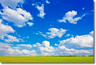
Weather Topic: What are Cumulus Clouds?
Home - Education - Cloud Types - Cumulus Clouds
 Next Topic: Drizzle
Cumulus clouds are fluffy and textured with rounded tops, and
may have flat bottoms. The border of a cumulus cloud
is clearly defined, and can have the appearance of cotton or cauliflower.
Cumulus clouds form at low altitudes (rarely above 2 km) but can grow very tall,
becoming cumulus congestus and possibly the even taller cumulonimbus clouds.
When cumulus clouds become taller, they have a greater chance of producing precipitation.
Next Topic: Drizzle
Current conditions powered by WeatherAPI.com


