Weather Alert in Wisconsin
Winter Storm Watch issued March 13 at 9:36PM CDT until March 16 at 7:00PM CDT by NWS Milwaukee/Sullivan WI
AREAS AFFECTED: Iowa; Dane; Jefferson; Waukesha; Milwaukee; Lafayette; Green; Rock; Walworth; Racine; Kenosha
DESCRIPTION: ...A PROLONGED WINTER WEATHER EVENT IS EXPECTED THROUGH THE LAST HALF OF THE WEEKEND AND THROUGH MONDAY... .A strong late winter storm system is expected to impact southern Wisconsin during the last half of the weekend in 3 phases: The first phase will run from Saturday night into Sunday morning and will feature a Winter Weather Advisory. During this time, snow accumulations of 1 to 3 inches are expected in the advisory area along with the potential for around a tenth of an inch of ice accumulation. The second phase is then expected from Sunday late morning into Sunday afternoon as warm air causes a transition to rain over a majority of southern Wisconsin. Thunderstorms may occur during this time. The last phase will then run from late Sunday afternoon through Monday as cold air then wraps back into the area and heavy banded snow moves in. Snowfall totals from 5 to 9 inches will result. A light glaze of ice may also occur, especially over central and east central Wisconsin. Wind gusts up to 45 mph will cause blowing snow and visibility restrictions. Hazardous travel is expected during both headline time frames. * WHAT...Heavy mixed precipitation possible. Total snow accumulations between 4 and 7 inches and ice accumulations around one tenth of an inch possible. Winds could gust as high as 45 mph. * WHERE...Portions of south central and southeast Wisconsin. * WHEN...From Sunday afternoon through Monday evening. * IMPACTS...Visibilities may drop below 1/4 mile due to falling and blowing snow. The strong winds and weight of snow on tree limbs may down power lines and could cause sporadic power outages. Travel could be very difficult. The hazardous conditions could impact the Monday morning and evening commutes. Gusty winds could bring down tree branches.
INSTRUCTION: Monitor the latest forecasts for updates on this situation.
Want more detail? Get the Complete 7 Day and Night Detailed Forecast!
Current U.S. National Radar--Current
The Current National Weather Radar is shown below with a UTC Time (subtract 5 hours from UTC to get Eastern Time).

National Weather Forecast--Current
The Current National Weather Forecast and National Weather Map are shown below.

National Weather Forecast for Tomorrow
Tomorrow National Weather Forecast and Tomorrow National Weather Map are show below.

North America Water Vapor (Moisture)
This map shows recent moisture content over North America. Bright and colored areas show high moisture (ie, clouds); brown indicates very little moisture present; black indicates no moisture.

Weather Topic: What is Graupel?
Home - Education - Precipitation - Graupel
 Next Topic: Hail
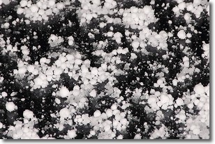
Graupel is a form of precipitation that is created by atmospheric conditions
which cause supercooled water droplets to contact snow crystals and freeze to
their surface.
Sometimes known as soft hail or snow pellets, graupel is delicate and easily
destroyed by touch. Whereas hail usually falls during severe weather, graupel
doesn't require such conditions to form, and can form in mild precipitation
similar to situations which produce snowfall.
Next Topic: Hail
Weather Topic: What are Hole Punch Clouds?
Home - Education - Cloud Types - Hole Punch Clouds
 Next Topic: Mammatus Clouds
A hole punch cloud is an unusual occurrence when a disk-shaped
hole appears in a cirrostratus, cirrocumulus, or altocumulus cloud.
When part of the cloud forms ice crystals, water droplets in the surrounding area
of the cloud evaporate. The effect of this process produces a large elliptical
gap in the cloud. The hole punch cloud formation is rare, but it is not specific
to any geographic area.
Other names which have been used to describe this phenomena include fallstreak hole,
skypunch, and cloud hole.
Next Topic: Mammatus Clouds
Current conditions powered by WeatherAPI.com


