Weather Alert in Michigan
Hydrologic Outlook issued February 17 at 9:43AM EST by NWS Grand Rapids MI
AREAS AFFECTED: Allegan, MI; Barry, MI; Calhoun, MI; Clinton, MI; Eaton, MI; Ingham, MI; Ionia, MI; Jackson, MI; Kalamazoo, MI; Kent, MI; Muskegon, MI; Ottawa, MI; Van Buren, MI
DESCRIPTION: ESFGRR Steady melting of snow and ice over the last week has begun to cause rivers to rise across the area. Several chances for rain this week will add to these rises. Based on current expected rainfall, no significant flooding is expected on West Michigan rivers, though typical spring water level rises within the river channels will happen. Meanwhile, river ice has weakened significantly over the last week, and as water levels rise any remaining ice will likely be broken and start to move downstream. This creates the possibility for formation of a few ice jams. Ice jams tend to form in the same places repeatedly, so special attention should be paid in the Comstock Park (Kent County) area as well as the Robinson Township (Ottawa County) area along the Grand River. Anyone living or working near West Michigan rivers should pay extra attention this week as water levels rise. Have a plan to monitor and respond if flooding develops unexpectedly. Monitor the latest conditions at https://water.noaa.gov
INSTRUCTION: N/A
Want more detail? Get the Complete 7 Day and Night Detailed Forecast!
Current U.S. National Radar--Current
The Current National Weather Radar is shown below with a UTC Time (subtract 5 hours from UTC to get Eastern Time).

National Weather Forecast--Current
The Current National Weather Forecast and National Weather Map are shown below.

National Weather Forecast for Tomorrow
Tomorrow National Weather Forecast and Tomorrow National Weather Map are show below.

North America Water Vapor (Moisture)
This map shows recent moisture content over North America. Bright and colored areas show high moisture (ie, clouds); brown indicates very little moisture present; black indicates no moisture.

Weather Topic: What are Contrails?
Home - Education - Cloud Types - Contrails
 Next Topic: Cumulonimbus Clouds
A contrail is an artificial cloud, created by the passing of an
aircraft.
Contrails form because water vapor in the exhaust of aircraft engines is suspended
in the air under certain temperatures and humidity conditions. These contrails
are called exhaust contrails.
Another type of contrail can form due to a temporary reduction in air pressure
moving over the plane's surface, causing condensation.
These are called aerodynamic contrails.
When you can see your breath on a cold day, it is also because of condensation.
The reason contrails last longer than the condensation from your breath is
because the water in contrails freezes into ice particles.
Next Topic: Cumulonimbus Clouds
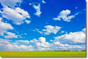
Weather Topic: What are Cumulus Clouds?
Home - Education - Cloud Types - Cumulus Clouds
 Next Topic: Drizzle
Cumulus clouds are fluffy and textured with rounded tops, and
may have flat bottoms. The border of a cumulus cloud
is clearly defined, and can have the appearance of cotton or cauliflower.
Cumulus clouds form at low altitudes (rarely above 2 km) but can grow very tall,
becoming cumulus congestus and possibly the even taller cumulonimbus clouds.
When cumulus clouds become taller, they have a greater chance of producing precipitation.
Next Topic: Drizzle
Current conditions powered by WeatherAPI.com


