Weather Alert in Colorado
Air Quality Alert issued June 18 at 4:10PM MDT by NWS Denver CO
AREAS AFFECTED: Adams, CO; Weld, CO; Jefferson, CO; Larimer, CO; Denver, CO; Douglas, CO; Broomfield, CO; Boulder, CO; Arapahoe, CO
DESCRIPTION: The Colorado Department of Public Health and Environment has issued the following... WHAT...Ozone Action Day Alert. WHERE...Douglas, Jefferson, Denver, western Arapahoe, western Adams, Broomfield, Boulder, Larimer, and Weld Counties WHEN...400 PM Wednesday June 18 to 400 PM Thursday June 19 IMPACTS...Ozone Action Day Alert is now in effect for the Front Range Urban Corridor. Ozone is expected to be in the Good to Moderate range on Wednesday. However, hot, sunny, and stagnant weather will allow ozone to reach the Unhealthy for Sensitive Groups category on Thursday. The highest ozone concentrations are expected in southern and western portions of the Denver Metro area, along the I-25 corridor towards Fort Collins, and Greeley. For Colorado air quality conditions, forecasts, and advisories, visit: https://www.colorado.gov/airquality/colorado_summary.aspx If possible, please help us reduce ozone pollution by limiting driving gas and diesel-powered vehicles until at least 4 p.m. Thursday, June 19, 2025. Colorado is also addressing ozone pollution through state policies. For more information about health impacts and how ozone pollution forms in Colorado, visit: https://cdphe.colorado.gov/ozone- pollution-and-your-health HEALTH INFORMATION...Increasing likelihood of respiratory symptoms and breathing discomfort in active children and adults and people with lung disease, such as asthma. Active children and adults, and people with lung disease, such as asthma, should reduce prolonged or heavy outdoor exertion.
INSTRUCTION: N/A
Want more detail? Get the Complete 7 Day and Night Detailed Forecast!
Current U.S. National Radar--Current
The Current National Weather Radar is shown below with a UTC Time (subtract 5 hours from UTC to get Eastern Time).

National Weather Forecast--Current
The Current National Weather Forecast and National Weather Map are shown below.

National Weather Forecast for Tomorrow
Tomorrow National Weather Forecast and Tomorrow National Weather Map are show below.

North America Water Vapor (Moisture)
This map shows recent moisture content over North America. Bright and colored areas show high moisture (ie, clouds); brown indicates very little moisture present; black indicates no moisture.

Weather Topic: What is Fog?
Home - Education - Cloud Types - Fog
 Next Topic: Fractus Clouds
Fog is technically a type of stratus cloud, which lies along the
ground and obscures visibility.
It is usually created when humidity in the air condenses into tiny water droplets.
Because of this, some places are more prone to foggy weather, such as regions
close to a body of water.
Fog is similar to mist; both are the appearance of water droplets suspended in
the air, but fog is the term applied to the condition when visibility is less than 1 km.
Next Topic: Fractus Clouds
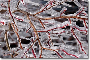
Weather Topic: What is Freezing Rain?
Home - Education - Precipitation - Freezing Rain
 Next Topic: Graupel
Freezing rain is a condition where precipitation which has fallen in the form of
water droplets reaches temperatures which are below freezing and freezes upon
coming into contact
with surface objects. The result of this precipitation is a glaze of ice which
can be damaging to plants and man-made structures. A severe onset of freezing
rain which results in a very thick glaze of ice is known as an ice storm.
Next Topic: Graupel
Current conditions powered by WeatherAPI.com


