Weather Alert in Colorado
Fire Weather Watch issued June 19 at 1:29AM MDT until June 21 at 10:00PM MDT by NWS Pueblo CO
AREAS AFFECTED: Upper Arkansas River Valley Including Lake County and Chaffee County; Eastern San Juan Mountains and La Garita Mountains Including Wolf Creek Pass and Creede
DESCRIPTION: The National Weather Service in Pueblo has issued a Red Flag Warning for gusty winds and low relative humidity, which is in effect from 10 AM to 10 PM MDT Friday. The Fire Weather Watch is no longer in effect. * AFFECTED AREA...Fire Weather Zones 220 and 223. * TIMING...For the Red Flag Warning, from 10 AM to 10 PM MDT Friday. For the Fire Weather Watch, from Saturday morning through Saturday evening. * WINDS...For Friday, southwest winds 15 to 25 mph with gusts to 40 mph. For Saturday, southwest winds 20 to 30 mph with gusts to 50 mph * RELATIVE HUMIDITY...For Friday, as low as 12 percent. For Saturday, as low as 9 percent. * IMPACTS...Elevated fire danger is expected. Fires will catch and spread rapidly and erratically.
INSTRUCTION: A Red Flag Warning means that critical fire weather conditions are either occurring now, or will shortly. A combination of strong winds, low relative humidity, and warm temperatures can contribute to extreme fire behavior. A Fire Weather Watch means that critical fire weather conditions are forecast to occur. Listen for later forecasts and possible Red Flag Warnings.
Want more detail? Get the Complete 7 Day and Night Detailed Forecast!
Current U.S. National Radar--Current
The Current National Weather Radar is shown below with a UTC Time (subtract 5 hours from UTC to get Eastern Time).

National Weather Forecast--Current
The Current National Weather Forecast and National Weather Map are shown below.

National Weather Forecast for Tomorrow
Tomorrow National Weather Forecast and Tomorrow National Weather Map are show below.

North America Water Vapor (Moisture)
This map shows recent moisture content over North America. Bright and colored areas show high moisture (ie, clouds); brown indicates very little moisture present; black indicates no moisture.

Weather Topic: What is Condensation?
Home - Education - Precipitation - Condensation
 Next Topic: Contrails
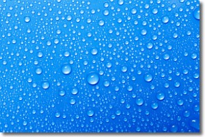
Condensation is the process which creates clouds, and therefore
it is a crucial process in the water cycle.
Condensation is the change of matter from a state of gas into a state of liquid,
and it happens because water molecules release heat into the atmosphere and
become organized into a more closely packed structure, what we might see as
water droplets.
Water is always present in the air around us as a vapor, but it's too small for
us to see. When water undergoes the process of condensation it becomes organized
into visible water droplets. You've probably seen condensation happen before on the
surface of a cold drink!
Next Topic: Contrails
Weather Topic: What are Cumulonimbus Clouds?
Home - Education - Cloud Types - Cumulonimbus Clouds
 Next Topic: Cumulus Clouds
The final form taken by a growing cumulus cloud is the
cumulonimbus cloud, which is very tall and dense.
The tower of a cumulonimbus cloud can soar 23 km into the atmosphere, although
most commonly they stop growing at an altitude of 6 km.
Even small cumulonimbus clouds appear very large in comparison to other cloud types.
They can signal the approach of stormy weather, such as thunderstorms or blizzards.
Next Topic: Cumulus Clouds
Current conditions powered by WeatherAPI.com


