Weather Alert in Washington
Winter Storm Warning issued March 12 at 1:37AM PDT until March 14 at 5:00AM PDT by NWS Spokane WA
AREAS AFFECTED: Western Chelan County
DESCRIPTION: * WHAT...For the Blizzard Warning, blizzard conditions expected. Additional snow accumulations 2 to 4 inches. Wind gusts will peak around 50 mph Thursday morning. For the Winter Storm Warning starting Thursday morning, heavy snow expected. Additional snow accumulations between 1 and 3 feet Thursday morning through Friday night. * WHERE...Holden Village and Stevens Pass. * WHEN...For the Blizzard Warning, until 5 AM PDT early this morning. For the Winter Storm Warning, from 5 AM early this morning to 5 AM PDT Saturday. * IMPACTS...Travel could be very difficult. Visibilities may drop below 1/4 mile due to falling and blowing snow during the blizzard warning. Strong winds could cause tree damage Thursday morning. * ADDITIONAL DETAILS...Colder air will arrive early Thursday morning with temperatures dropping back into the 20s. Through Friday night, periods of snow expected at Stehekin. Snow will change to rain each afternoon. Total accumulations around 5 to 8 inches at Stehekin.
INSTRUCTION: If you must travel, have a winter survival kit with you. If you get stranded, stay with your vehicle. For the latest travel information in Washington, go to https://wsdot.wa.gov/travel If travel is absolutely necessary, drive with extreme caution and be prepared for sudden changes in visibility. Leave plenty of room between you and the motorist ahead of you, and allow extra time to reach your destination. Avoid sudden braking or acceleration, and be especially cautious on hills or when making turns. Make sure your car is winterized and in good working order. If you must travel, keep an extra flashlight, food, and water in your vehicle in case of an emergency. For the latest travel information in Washington, go to https://wsdot.wa.gov/travel
Want more detail? Get the Complete 7 Day and Night Detailed Forecast!
Current U.S. National Radar--Current
The Current National Weather Radar is shown below with a UTC Time (subtract 5 hours from UTC to get Eastern Time).

National Weather Forecast--Current
The Current National Weather Forecast and National Weather Map are shown below.

National Weather Forecast for Tomorrow
Tomorrow National Weather Forecast and Tomorrow National Weather Map are show below.

North America Water Vapor (Moisture)
This map shows recent moisture content over North America. Bright and colored areas show high moisture (ie, clouds); brown indicates very little moisture present; black indicates no moisture.

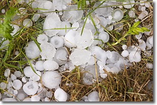
Weather Topic: What is Hail?
Home - Education - Precipitation - Hail
 Next Topic: Hole Punch Clouds
Hail is a form of precipitation which is recognized by large solid balls or
clumps of ice. Hail is created by thunderstorm clouds with strong updrafts of wind.
As the hailstones remain in the updraft, ice is deposited onto them until their
weight becomes heavy enough for them to fall to the earth's surface.
Hail storms can cause significant damage to crops, aircrafts, and man-made structures,
despite the fact that the duration is usually less than ten minutes.
Next Topic: Hole Punch Clouds
Weather Topic: What are Mammatus Clouds?
Home - Education - Cloud Types - Mammatus Clouds
 Next Topic: Nimbostratus Clouds
A mammatus cloud is a cloud with a unique feature which resembles
a web of pouches hanging along the base of the cloud.
In the United States, mammatus clouds tend to form in the warmer months, commonly
in the Midwest and eastern regions.
While they usually form at the bottom of a cumulonimbis cloud, they can also form
under altostratus, altocumulus, stratocumulus, and cirrus clouds. Mammatus clouds
warn that severe weather is close.
Next Topic: Nimbostratus Clouds
Current conditions powered by WeatherAPI.com


