Weather Alert in Montana
Avalanche Watch issued March 11 at 7:39AM MDT by NWS Missoula MT
AREAS AFFECTED: Kootenai/Cabinet Region
DESCRIPTION: AVAMSO The following message is transmitted at the request of Idaho Panhandle Avalanche Center Sandpoint ID. ...AVALANCHE WATCH ISSUED BY THE IDAHO PANHANDLE AVALANCHE CENTER... 07:00 PDT Wed Mar 11 2026 The Idaho Panhandle Avalanche Center in Sandpoint has issued a BACKCOUNTRY AVALANCHE WATCH for the following areas: NWS Missoula MT - MTZ001 (MTZ001) NWS Spokane WA - ID 017 (Bonner County)...ID 021 (Boundary County)...ID 079 (Shoshone County) * WHAT...An Avalanche Watch is in effect from Wednesday 7 AM PST to Thursday 7 AM PST. Very dangerous avalanche conditions are likely to develop by Thursday morning and raise the danger to High (Level 4of5). * WHERE...The Selkirk, West and East Cabinet, Purcell, and Bitterroot Mountains - Silver Valley above 4,000 feet. * WHEN...In effect from Wed 07:00 PDT to Thu 07:00 PDT. * IMPACTS...An atmospheric river and violent jet stream join forces to deliver moderate to heavy snowfall and strong to extreme winds. Snowfall is expected to be measured in feet not inches and the new snow will form dangerous slabs of snow, and may cause a widespread cycle of avalanches large enough to bury, injure, or kill a person. It will become very easy for backcountry travelers to trigger them. * PRECAUTIONARY / PREPAREDNESS ACTIONS...Travel in or below avalanche terrain is not recommended during this period. Consult http://www.idahopanhandleavalanche.org/ or www.avalanche.org for more detailed information. Similar avalanche danger may exist at locations outside the coverage area of this or any avalanche center.
INSTRUCTION: N/A
Want more detail? Get the Complete 7 Day and Night Detailed Forecast!
Current U.S. National Radar--Current
The Current National Weather Radar is shown below with a UTC Time (subtract 5 hours from UTC to get Eastern Time).

National Weather Forecast--Current
The Current National Weather Forecast and National Weather Map are shown below.

National Weather Forecast for Tomorrow
Tomorrow National Weather Forecast and Tomorrow National Weather Map are show below.

North America Water Vapor (Moisture)
This map shows recent moisture content over North America. Bright and colored areas show high moisture (ie, clouds); brown indicates very little moisture present; black indicates no moisture.

Weather Topic: What are Contrails?
Home - Education - Cloud Types - Contrails
 Next Topic: Cumulonimbus Clouds
A contrail is an artificial cloud, created by the passing of an
aircraft.
Contrails form because water vapor in the exhaust of aircraft engines is suspended
in the air under certain temperatures and humidity conditions. These contrails
are called exhaust contrails.
Another type of contrail can form due to a temporary reduction in air pressure
moving over the plane's surface, causing condensation.
These are called aerodynamic contrails.
When you can see your breath on a cold day, it is also because of condensation.
The reason contrails last longer than the condensation from your breath is
because the water in contrails freezes into ice particles.
Next Topic: Cumulonimbus Clouds
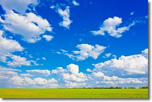
Weather Topic: What are Cumulus Clouds?
Home - Education - Cloud Types - Cumulus Clouds
 Next Topic: Drizzle
Cumulus clouds are fluffy and textured with rounded tops, and
may have flat bottoms. The border of a cumulus cloud
is clearly defined, and can have the appearance of cotton or cauliflower.
Cumulus clouds form at low altitudes (rarely above 2 km) but can grow very tall,
becoming cumulus congestus and possibly the even taller cumulonimbus clouds.
When cumulus clouds become taller, they have a greater chance of producing precipitation.
Next Topic: Drizzle
Current conditions powered by WeatherAPI.com


