Weather Alert in Arizona
Dust Storm Warning issued August 25 at 5:39PM MST until August 25 at 6:45PM MST by NWS Phoenix AZ
AREAS AFFECTED: Maricopa, AZ
DESCRIPTION: The National Weather Service in Phoenix has issued a * Dust Storm Warning for... Maricopa County in south central Arizona... * Until 645 PM MST. * At 538 PM MST, a wall of dust was along a line extending from Camelback Mountain to Downtown Phoenix to South Mountain Park, moving west at 25 mph. HAZARD...Near zero visibility with strong wind in excess of 50 mph. SOURCE...Doppler radar. IMPACT...Dangerous life-threatening travel. * This includes the following highways... AZ Interstate 10 between mile markers 119 and 147. AZ Interstate 17 between mile markers 195 and 218. AZ Route 51 between mile markers 1 and 10. Locations impacted include... Phoenix, Glendale, Peoria, Surprise, Avondale, Goodyear, Buckeye, El Mirage, Paradise Valley, Tolleson, Youngtown, Sun City West, Waddell, Laveen, and Cashion.
INSTRUCTION: Dust storms lead to dangerous driving conditions with visibility reduced to near zero. If driving, avoid dust storms if possible. If caught in one, pull off the road, turn off your lights and keep your foot off the brake.
Want more detail? Get the Complete 7 Day and Night Detailed Forecast!
Current U.S. National Radar--Current
The Current National Weather Radar is shown below with a UTC Time (subtract 5 hours from UTC to get Eastern Time).

National Weather Forecast--Current
The Current National Weather Forecast and National Weather Map are shown below.

National Weather Forecast for Tomorrow
Tomorrow National Weather Forecast and Tomorrow National Weather Map are show below.

North America Water Vapor (Moisture)
This map shows recent moisture content over North America. Bright and colored areas show high moisture (ie, clouds); brown indicates very little moisture present; black indicates no moisture.

Weather Topic: What is Snow?
Home - Education - Precipitation - Snow
 Next Topic: Stratocumulus Clouds
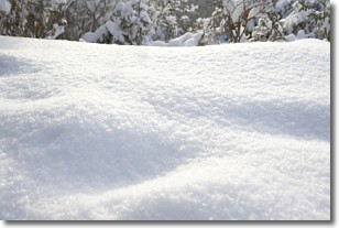
Snow is precipitation taking the form of ice crystals. Each ice crystal, or snowflake,
has unique characteristics, but all of them grow in a hexagonal structure.
Snowfall can last for sustained periods of time and result in significant buildup
of snow on the ground.
On the earth's surface, snow starts out light and powdery, but as it begins to melt
it tends to become more granular, producing small bits of ice which have the consistency of
sand. After several cycles of melting and freezing, snow can become very dense
and ice-like, commonly known as snow pack.
Next Topic: Stratocumulus Clouds
Weather Topic: What are Stratus Clouds?
Home - Education - Cloud Types - Stratus Clouds
 Next Topic: Wall Clouds
Stratus clouds are similar to altostratus clouds, but form at a
lower altitude and are identified by their fog-like appearance, lacking the
distinguishing features of most clouds.
Stratus clouds are wider than most clouds, and their base has a smooth, uniform
look which is lighter in color than a nimbostratus cloud.
The presence of a stratus cloud indicates the possibility of minor precipitation,
such as drizzle, but heavier precipitation does not typically arrive in the form
of a stratus cloud.
Next Topic: Wall Clouds
Current conditions powered by WeatherAPI.com


