Weather Alert in Montana
High Wind Warning issued February 16 at 1:31PM MST until February 17 at 8:00PM MST by NWS Billings MT
AREAS AFFECTED: Absaroka/Beartooth Mountains
DESCRIPTION: * WHAT...Southwest wind gusts up to 80 mph expected with whiteout conditions in blowing snow. * WHERE...Absaroka/Beartooth Mountains. * WHEN...From 5 AM to 8 PM MST Tuesday. * IMPACTS...Combination of snow and blowing snow due to the strong winds will create white out conditions at times. Tree damage and significant blowing snow are also expected. Back country recreation is strongly discouraged! Travel between Gardiner and Cooke City will be difficult to impossible at times. * ADDITIONAL DETAILS...Avalanche danger will increase.
INSTRUCTION: Delay travel to Cooke City, and do not venture into the back country until winds subside.
Want more detail? Get the Complete 7 Day and Night Detailed Forecast!
Current U.S. National Radar--Current
The Current National Weather Radar is shown below with a UTC Time (subtract 5 hours from UTC to get Eastern Time).

National Weather Forecast--Current
The Current National Weather Forecast and National Weather Map are shown below.

National Weather Forecast for Tomorrow
Tomorrow National Weather Forecast and Tomorrow National Weather Map are show below.

North America Water Vapor (Moisture)
This map shows recent moisture content over North America. Bright and colored areas show high moisture (ie, clouds); brown indicates very little moisture present; black indicates no moisture.

Weather Topic: What is Condensation?
Home - Education - Precipitation - Condensation
 Next Topic: Contrails
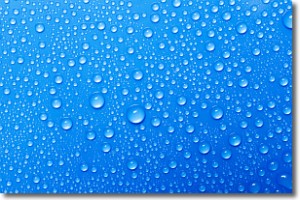
Condensation is the process which creates clouds, and therefore
it is a crucial process in the water cycle.
Condensation is the change of matter from a state of gas into a state of liquid,
and it happens because water molecules release heat into the atmosphere and
become organized into a more closely packed structure, what we might see as
water droplets.
Water is always present in the air around us as a vapor, but it's too small for
us to see. When water undergoes the process of condensation it becomes organized
into visible water droplets. You've probably seen condensation happen before on the
surface of a cold drink!
Next Topic: Contrails
Weather Topic: What are Cumulonimbus Clouds?
Home - Education - Cloud Types - Cumulonimbus Clouds
 Next Topic: Cumulus Clouds
The final form taken by a growing cumulus cloud is the
cumulonimbus cloud, which is very tall and dense.
The tower of a cumulonimbus cloud can soar 23 km into the atmosphere, although
most commonly they stop growing at an altitude of 6 km.
Even small cumulonimbus clouds appear very large in comparison to other cloud types.
They can signal the approach of stormy weather, such as thunderstorms or blizzards.
Next Topic: Cumulus Clouds
Current conditions powered by WeatherAPI.com


