Weather Alert in California
Winter Weather Advisory issued February 18 at 5:26PM PST until February 20 at 7:00AM PST by NWS San Francisco CA
AREAS AFFECTED: Santa Lucia Mountains and Los Padres National Forest; Mountains Of San Benito County And Interior Monterey County Including Pinnacles National Park
DESCRIPTION: * WHAT...Accumulating snow for elevations above 3500 feet. Elevations below 3000 feet will see no accumulating snow to a wet slushy inch. Above 3500 feet total snow accumulations of 2 to 5 inches and above 4500 feet up to 9 inches. * WHERE...Interior Monterey County and the Santa Lucia Range, and Most of San Benito County and the Cholame Hills in Southeast Monterey County. * WHEN...From midnight tonight to 7 AM PST Friday. * IMPACTS...Slick, snow-covered roads and hiking trails. Hikers, campers, outdoor enthusiasts may encounter dangerous winter conditions above the snow level. Heavier snow showers could produce limited visibilities. Downed trees and power outages possible. * ADDITIONAL DETAILS...Wind gusts 40 to 50 mph above 2000 feet. The combination of wind and snow will reduce visibilities with blizzard like conditions over the highest peaks.
INSTRUCTION: Slow down and use caution while traveling.
Want more detail? Get the Complete 7 Day and Night Detailed Forecast!
Current U.S. National Radar--Current
The Current National Weather Radar is shown below with a UTC Time (subtract 5 hours from UTC to get Eastern Time).

National Weather Forecast--Current
The Current National Weather Forecast and National Weather Map are shown below.

National Weather Forecast for Tomorrow
Tomorrow National Weather Forecast and Tomorrow National Weather Map are show below.

North America Water Vapor (Moisture)
This map shows recent moisture content over North America. Bright and colored areas show high moisture (ie, clouds); brown indicates very little moisture present; black indicates no moisture.

Weather Topic: What is Freezing Rain?
Home - Education - Precipitation - Freezing Rain
 Next Topic: Graupel
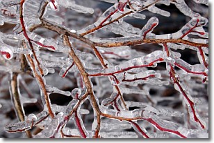
Freezing rain is a condition where precipitation which has fallen in the form of
water droplets reaches temperatures which are below freezing and freezes upon
coming into contact
with surface objects. The result of this precipitation is a glaze of ice which
can be damaging to plants and man-made structures. A severe onset of freezing
rain which results in a very thick glaze of ice is known as an ice storm.
Next Topic: Graupel
Weather Topic: What is Hail?
Home - Education - Precipitation - Hail
 Next Topic: Hole Punch Clouds
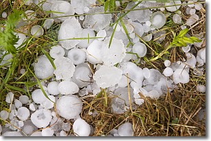
Hail is a form of precipitation which is recognized by large solid balls or
clumps of ice. Hail is created by thunderstorm clouds with strong updrafts of wind.
As the hailstones remain in the updraft, ice is deposited onto them until their
weight becomes heavy enough for them to fall to the earth's surface.
Hail storms can cause significant damage to crops, aircrafts, and man-made structures,
despite the fact that the duration is usually less than ten minutes.
Next Topic: Hole Punch Clouds
Current conditions powered by WeatherAPI.com


