Weather Alert in Washington
Winter Storm Warning issued March 12 at 2:01AM PDT until March 13 at 5:00AM PDT by NWS Portland OR
AREAS AFFECTED: South Washington Cascades
DESCRIPTION: * WHAT...Heavy snow expected above 2500 ft. Additional snow accumulations of 10 to 18 inches with up to 25 inches along the volcanos. Winds gusting as high as 35 mph, except up to 45 mph along the peaks. * WHERE...South Washington Cascades. * WHEN...Until 5 AM PDT Friday. * IMPACTS...Roads, and especially bridges and overpasses, will likely become slick and hazardous.
INSTRUCTION: Consider postponing travel until weather conditions improve. If you must travel, be sure to slow down and allow extra time. If your car becomes trapped in deep snow, be sure to keep your car off to stay safe from potential carbon monoxide poisoning. If you are using a generator, be sure to keep it outdoors and away from windows and vents. Be aware that walking surfaces may be slick. Walk with extra care. Backcountry recreation is not advised.
Want more detail? Get the Complete 7 Day and Night Detailed Forecast!
Current U.S. National Radar--Current
The Current National Weather Radar is shown below with a UTC Time (subtract 5 hours from UTC to get Eastern Time).

National Weather Forecast--Current
The Current National Weather Forecast and National Weather Map are shown below.

National Weather Forecast for Tomorrow
Tomorrow National Weather Forecast and Tomorrow National Weather Map are show below.

North America Water Vapor (Moisture)
This map shows recent moisture content over North America. Bright and colored areas show high moisture (ie, clouds); brown indicates very little moisture present; black indicates no moisture.

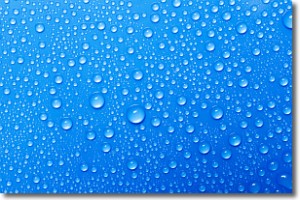
Weather Topic: What is Condensation?
Home - Education - Precipitation - Condensation
 Next Topic: Contrails
Condensation is the process which creates clouds, and therefore
it is a crucial process in the water cycle.
Condensation is the change of matter from a state of gas into a state of liquid,
and it happens because water molecules release heat into the atmosphere and
become organized into a more closely packed structure, what we might see as
water droplets.
Water is always present in the air around us as a vapor, but it's too small for
us to see. When water undergoes the process of condensation it becomes organized
into visible water droplets. You've probably seen condensation happen before on the
surface of a cold drink!
Next Topic: Contrails
Weather Topic: What are Cumulonimbus Clouds?
Home - Education - Cloud Types - Cumulonimbus Clouds
 Next Topic: Cumulus Clouds
The final form taken by a growing cumulus cloud is the
cumulonimbus cloud, which is very tall and dense.
The tower of a cumulonimbus cloud can soar 23 km into the atmosphere, although
most commonly they stop growing at an altitude of 6 km.
Even small cumulonimbus clouds appear very large in comparison to other cloud types.
They can signal the approach of stormy weather, such as thunderstorms or blizzards.
Next Topic: Cumulus Clouds
Current conditions powered by WeatherAPI.com


