Weather Alert in Washington
Flood Warning issued March 10 at 7:08PM PDT until March 14 at 8:00PM PDT by NWS Spokane WA
AREAS AFFECTED: Chelan, WA
DESCRIPTION: * WHAT...Flooding caused by rain and snowmelt is expected for the lower Stehekin Valley. * WHERE...A portion of North Central Washington, including the following county, Chelan. * WHEN...Until 800 PM PDT Saturday. * IMPACTS...When the Stehekin River gauge hits 19.3 feet, water breaches the river bank. At 20 feet, water inundates some properties and overtops the temporary corduroy bridge. Company Creek Road is beginning to flood in places at the northern end. Battalion Creek culverts are beginning to be overtopped. At 20.5 feet, water begins to damage Wood Road. * ADDITIONAL DETAILS... - At 657 PM PDT, the Stehekin River was above Action Stage. Flooding is ongoing or expected Flooding is ongoing or expected to begin shortly. the warned area. - Additional rainfall amounts of 0.5 to 1.5 inches are possible in the warned area through Saturday evening. A period of moderate to heavy rain and high winds will lead to rapid snowmelt Wednesday night into Thursday. A secondary peak of 19.8 feet is forecast Thursday afternoon. - Some locations that will experience flooding include... Company Creek Campground. - http://www.weather.gov/safety/flood
INSTRUCTION: Turn around, don't drown when encountering flooded roads. Most flood deaths occur in vehicles.
Want more detail? Get the Complete 7 Day and Night Detailed Forecast!
Current U.S. National Radar--Current
The Current National Weather Radar is shown below with a UTC Time (subtract 5 hours from UTC to get Eastern Time).

National Weather Forecast--Current
The Current National Weather Forecast and National Weather Map are shown below.

National Weather Forecast for Tomorrow
Tomorrow National Weather Forecast and Tomorrow National Weather Map are show below.

North America Water Vapor (Moisture)
This map shows recent moisture content over North America. Bright and colored areas show high moisture (ie, clouds); brown indicates very little moisture present; black indicates no moisture.

Weather Topic: What is Freezing Rain?
Home - Education - Precipitation - Freezing Rain
 Next Topic: Graupel
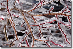
Freezing rain is a condition where precipitation which has fallen in the form of
water droplets reaches temperatures which are below freezing and freezes upon
coming into contact
with surface objects. The result of this precipitation is a glaze of ice which
can be damaging to plants and man-made structures. A severe onset of freezing
rain which results in a very thick glaze of ice is known as an ice storm.
Next Topic: Graupel
Weather Topic: What is Hail?
Home - Education - Precipitation - Hail
 Next Topic: Hole Punch Clouds
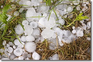
Hail is a form of precipitation which is recognized by large solid balls or
clumps of ice. Hail is created by thunderstorm clouds with strong updrafts of wind.
As the hailstones remain in the updraft, ice is deposited onto them until their
weight becomes heavy enough for them to fall to the earth's surface.
Hail storms can cause significant damage to crops, aircrafts, and man-made structures,
despite the fact that the duration is usually less than ten minutes.
Next Topic: Hole Punch Clouds
Current conditions powered by WeatherAPI.com


