Weather Alert in Washington
Flood Warning issued March 12 at 12:01AM PDT by NWS Seattle WA
AREAS AFFECTED: Mason, WA
DESCRIPTION: ...The National Weather Service in Seattle WA has issued a Flood Warning for the following rivers in Washington... Skokomish River At Potlatch affecting Mason County. .Heavy precipitation over the south slopes of the Olympics Wednesday will cause the Skokomish river to rise above flood stage Thursday morning. The river will drop below flood stage later Thursday. Precipitation early next week could cause additional flooding on the river. * WHAT...Minor flooding is forecast. * WHERE...Skokomish River at Potlatch. * WHEN...From late tonight until further notice. * IMPACTS...At 16.5 feet, the Skokomish River will cause widespread flooding of pasture lands, with water flowing quickly over West Bourgault Road and Skokomish Valley Road. * ADDITIONAL DETAILS... - At 11:30 PM PDT Wednesday the stage was 16.1 feet. - Flood stage is 16.5 feet. - Forecast...The river will rise to flood stage late tonight and crest around 16.8 feet Thursday morning. It will then fall back down below flood stage later Thursday afternoon or Thursday evening. The river could rise above flood stage again early next week. - http://www.weather.gov/safety/flood
INSTRUCTION: Turn around, don't drown when encountering flooded roads. Most flood deaths occur in vehicles. Motorists should not attempt to drive around barricades or drive cars through flooded areas. Additional information is available at www.weather.gov. The next statement will be issued by this morning at 815 AM PDT.
Want more detail? Get the Complete 7 Day and Night Detailed Forecast!
Current U.S. National Radar--Current
The Current National Weather Radar is shown below with a UTC Time (subtract 5 hours from UTC to get Eastern Time).

National Weather Forecast--Current
The Current National Weather Forecast and National Weather Map are shown below.

National Weather Forecast for Tomorrow
Tomorrow National Weather Forecast and Tomorrow National Weather Map are show below.

North America Water Vapor (Moisture)
This map shows recent moisture content over North America. Bright and colored areas show high moisture (ie, clouds); brown indicates very little moisture present; black indicates no moisture.

Weather Topic: What is Fog?
Home - Education - Cloud Types - Fog
 Next Topic: Fractus Clouds
Fog is technically a type of stratus cloud, which lies along the
ground and obscures visibility.
It is usually created when humidity in the air condenses into tiny water droplets.
Because of this, some places are more prone to foggy weather, such as regions
close to a body of water.
Fog is similar to mist; both are the appearance of water droplets suspended in
the air, but fog is the term applied to the condition when visibility is less than 1 km.
Next Topic: Fractus Clouds
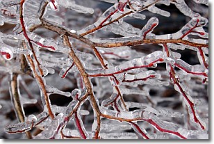
Weather Topic: What is Freezing Rain?
Home - Education - Precipitation - Freezing Rain
 Next Topic: Graupel
Freezing rain is a condition where precipitation which has fallen in the form of
water droplets reaches temperatures which are below freezing and freezes upon
coming into contact
with surface objects. The result of this precipitation is a glaze of ice which
can be damaging to plants and man-made structures. A severe onset of freezing
rain which results in a very thick glaze of ice is known as an ice storm.
Next Topic: Graupel
Current conditions powered by WeatherAPI.com


