Weather Alert in California
Fire Weather Watch issued June 19 at 12:24PM PDT until June 22 at 11:00AM PDT by NWS Sacramento CA
AREAS AFFECTED: Northern Sacramento Valley to Southern Tehama County Line Below 1000 Ft; Central Sacramento Valley including Glenn/Colusa/Yuba/Northern Sutter/Butte County Below 1000 Ft; Southern Sacramento Valley In Yolo/Sacramento/Far Western Placer/Southern Sutter and Solano County Below 1000 Ft - Excludes the Delta; Eastern Delta; Northern San Joaquin Valley in San Joaquin and Stanislaus Counties Below 1000 ft - Excludes the Delta; Southern Motherlode From 1000 to 3000 Ft/Calaveras and Toulumne Counties; Southeast Edge Shasta/Trinity NF and Western Portions of Tehama/Glenn RU; Northern Sierra Foothills from 1000 to 3000 Ft. Includes Nevada-Yuba-Placer RU and Anador-Eldorado RU; Eastern Mendocino NF
DESCRIPTION: The National Weather Service in Sacramento has issued a Fire Weather Watch for gusty winds and low humidity, which is in effect from Saturday morning through Sunday morning. * Winds...North winds 15 to 25 mph with gusts up of 30 to 40 mph. Strongest winds expected across the Sacramento Valley along and west of Interstate 5, the Delta, and the northern San Joaquin Valley. * Humidity...Minimum daytime humidity: 15 to 25 percent. Overnight recoveries in the mid 40s to mid 50s. * Highest Threat...Sacramento Valley along and west of the I-5 corridor, adjacent Coastal Range, and the northern San Joaquin Valley. * Impacts...The combination of gusty winds and low humidity can cause fire to rapidly grow in size and intensity. Outdoor burning is not recommended.
INSTRUCTION: A Fire Weather Watch means that critical fire weather conditions are forecast to occur. Listen for later forecasts and possible Red Flag Warnings.
Want more detail? Get the Complete 7 Day and Night Detailed Forecast!
Current U.S. National Radar--Current
The Current National Weather Radar is shown below with a UTC Time (subtract 5 hours from UTC to get Eastern Time).

National Weather Forecast--Current
The Current National Weather Forecast and National Weather Map are shown below.

National Weather Forecast for Tomorrow
Tomorrow National Weather Forecast and Tomorrow National Weather Map are show below.

North America Water Vapor (Moisture)
This map shows recent moisture content over North America. Bright and colored areas show high moisture (ie, clouds); brown indicates very little moisture present; black indicates no moisture.

Weather Topic: What is Fog?
Home - Education - Cloud Types - Fog
 Next Topic: Fractus Clouds
Fog is technically a type of stratus cloud, which lies along the
ground and obscures visibility.
It is usually created when humidity in the air condenses into tiny water droplets.
Because of this, some places are more prone to foggy weather, such as regions
close to a body of water.
Fog is similar to mist; both are the appearance of water droplets suspended in
the air, but fog is the term applied to the condition when visibility is less than 1 km.
Next Topic: Fractus Clouds
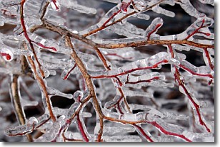
Weather Topic: What is Freezing Rain?
Home - Education - Precipitation - Freezing Rain
 Next Topic: Graupel
Freezing rain is a condition where precipitation which has fallen in the form of
water droplets reaches temperatures which are below freezing and freezes upon
coming into contact
with surface objects. The result of this precipitation is a glaze of ice which
can be damaging to plants and man-made structures. A severe onset of freezing
rain which results in a very thick glaze of ice is known as an ice storm.
Next Topic: Graupel
Current conditions powered by WeatherAPI.com


