Weather Alert in New York
Winter Storm Warning issued March 12 at 1:57PM EDT until March 14 at 2:00PM EDT by NWS Buffalo NY
AREAS AFFECTED: Oswego; Jefferson; Lewis
DESCRIPTION: * WHAT...Heavy snow expected. Total snow accumulations 8 to 15 inches. Winds gusting as high as 45 mph will produce blowing and drifting snow. * WHERE...The Eastern Lake Ontario Region. The greatest accumulations are expected across the Tug Hill and Western foothills of the Adirondacks. * WHEN...From 11 AM Friday to 2 PM EDT Saturday. * IMPACTS...Travel will be very difficult. The hazardous conditions will impact the Friday evening commute. Gusty winds will down tree branches and cause isolated power outages. * ADDITIONAL DETAILS...Accumulations of 2 to 4 inches are expected across the lower elevations of the North Country, including the Watertown Metro area. The strongest wind gusts are expected across the northern slopes of the Tug Hill and the eastern shoreline of Lake Ontario.
INSTRUCTION: Widespread accumulating snow will create dangerous travel conditions. Submit snow reports through our website or social media.
Want more detail? Get the Complete 7 Day and Night Detailed Forecast!
Current U.S. National Radar--Current
The Current National Weather Radar is shown below with a UTC Time (subtract 5 hours from UTC to get Eastern Time).

National Weather Forecast--Current
The Current National Weather Forecast and National Weather Map are shown below.

National Weather Forecast for Tomorrow
Tomorrow National Weather Forecast and Tomorrow National Weather Map are show below.

North America Water Vapor (Moisture)
This map shows recent moisture content over North America. Bright and colored areas show high moisture (ie, clouds); brown indicates very little moisture present; black indicates no moisture.

Weather Topic: What are Fractus Clouds?
Home - Education - Cloud Types - Fractus Clouds
 Next Topic: Freezing Rain
A fractus cloud (scud) is a fragmented, tattered cloud which has
likely been sheared off of another cloud. They are accessory clouds, meaning they
develop from parent clouds, and are named in a way which describes the original
cloud which contained them.
Fractus clouds which have originated from cumulus clouds are referred to as
cumulus fractus, while fractus clouds which have originated from stratus clouds
are referred to as stratus fractus. Under certain conditions a fractus cloud might
merge with another cloud, or develop into a cumulus cloud, but usually a
fractus cloud seen by itself will dissipate rapidly.
They are often observed on the leading and trailing edges of storm clouds,
and are a display of wind activity.
Next Topic: Freezing Rain
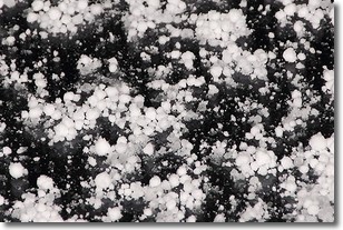
Weather Topic: What is Graupel?
Home - Education - Precipitation - Graupel
 Next Topic: Hail
Graupel is a form of precipitation that is created by atmospheric conditions
which cause supercooled water droplets to contact snow crystals and freeze to
their surface.
Sometimes known as soft hail or snow pellets, graupel is delicate and easily
destroyed by touch. Whereas hail usually falls during severe weather, graupel
doesn't require such conditions to form, and can form in mild precipitation
similar to situations which produce snowfall.
Next Topic: Hail
Current conditions powered by WeatherAPI.com


