Weather Alert in New Mexico
Red Flag Warning issued February 19 at 3:03AM MST until February 19 at 6:00PM MST by NWS Albuquerque NM
AREAS AFFECTED: Northeast Highlands
DESCRIPTION: ...RED FLAG WARNING TODAY FROM 12 TO 6 PM FOR THE NORTHEAST AND EAST CENTRAL PLAINS, AND THE NORTHEAST HIGHLANDS ALONG AND EAST OF I-25, DUE TO STRONG WINDS AND LOW HUMIDITY... ...FIRE WEATHER WATCH FRIDAY FROM 1 TO 6 PM FOR THE EASTERN PLAINS, AND FOR THE GUADALUPE COUNTY PORTION OF THE CENTRAL HIGHLANDS, DUE TO STRONG WINDS AND LOW HUMIDITY... .Persistently strong flow aloft, an area of low pressure at the surface over the northeast corner of New Mexico, and very dry fuels over northeast and east central areas will result in critical fire weather conditions on the eastern plains today and Friday. The critical fire weather conditions will reach as far west as the I-25 corridor from Las Vegas northward today, but higher humidities and snow showers should reduce fire weather concerns over the Northeast Highlands on Friday. Meanwhile, drier conditions are forecast across the eastern half of the Central Highlands on Friday, compared to today. So, Guadalupe County has been added to Friday's Fire Weather Watch. The strongest winds are forecast Friday, when gusts will probably reach 50 to 60 mph across much of northeast and east central New Mexico. The National Weather Service in Albuquerque has issued a Red Flag Warning...which is in effect from noon today to 6 PM MST this evening. * AREA AND TIMING...Red Flag Warning for Northeast Highlands (Zone 104), along and east of I-25 from Las Vegas northward, today from 12 PM until 6 PM MST. * 20 FOOT WINDS...West and northwest winds 20 to 30 mph with gusts around 40 mph. * RELATIVE HUMIDITY...Minimum values between 12 and 20 percent. * IMPACTS...Any fires that develop will likely spread rapidly. Outdoor burning is not recommended.
INSTRUCTION: Please advise the appropriate officials or fire crews in the field of this Red Flag Warning.
Want more detail? Get the Complete 7 Day and Night Detailed Forecast!
Current U.S. National Radar--Current
The Current National Weather Radar is shown below with a UTC Time (subtract 5 hours from UTC to get Eastern Time).

National Weather Forecast--Current
The Current National Weather Forecast and National Weather Map are shown below.

National Weather Forecast for Tomorrow
Tomorrow National Weather Forecast and Tomorrow National Weather Map are show below.

North America Water Vapor (Moisture)
This map shows recent moisture content over North America. Bright and colored areas show high moisture (ie, clouds); brown indicates very little moisture present; black indicates no moisture.

Weather Topic: What are Shelf Clouds?
Home - Education - Cloud Types - Shelf Clouds
 Next Topic: Sleet
A shelf cloud is similar to a wall cloud, but forms at the front
of a storm cloud, instead of at the rear, where wall clouds form.
A shelf cloud is caused by a series of events set into motion by the advancing
storm; first, cool air settles along the ground where precipitation has just fallen.
As the cool air is brought in, the warmer air is displaced, and rises above it,
because it is less dense. When the warmer air reaches the bottom of the storm cloud,
it begins to cool again, and the resulting condensation is a visible shelf cloud.
Next Topic: Sleet
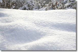
Weather Topic: What is Snow?
Home - Education - Precipitation - Snow
 Next Topic: Stratocumulus Clouds
Snow is precipitation taking the form of ice crystals. Each ice crystal, or snowflake,
has unique characteristics, but all of them grow in a hexagonal structure.
Snowfall can last for sustained periods of time and result in significant buildup
of snow on the ground.
On the earth's surface, snow starts out light and powdery, but as it begins to melt
it tends to become more granular, producing small bits of ice which have the consistency of
sand. After several cycles of melting and freezing, snow can become very dense
and ice-like, commonly known as snow pack.
Next Topic: Stratocumulus Clouds
Current conditions powered by WeatherAPI.com


