Weather Alert in Indiana
Air Quality Alert issued June 5 at 11:56AM EDT by NWS Northern Indiana
AREAS AFFECTED: Elkhart; Lagrange; Steuben; Noble; De Kalb; Starke; Pulaski; Marshall; Fulton; Whitley; Allen; Cass; Miami; Wabash; Huntington; Wells; Adams; Grant; Blackford; Jay; Northern La Porte; Eastern St. Joseph; Northern Kosciusko; Southern La Porte; Western St. Joseph; Southern Kosciusko
DESCRIPTION: The officials at the Indiana Department of Environmental Management have declared Air Quality Action Days, in effect for Thursday June 5 and Friday June 6. Air Quality Action Days for PM 2.5 have been issued through Friday, mainly due to smoke from Canadian wildfires. The associated fine particulate levels are expected to be in the Unhealthy for Sensitive Groups range. Active children and adults, and people with respiratory disease, such as asthma should limit prolonged outdoor exposure. Here are some recommended actions that the public can take: * Walk, bike, carpool or use public transportation. * Avoid using the drive-through and combine errands into one trip. * Avoid refueling your vehicle or using gasoline-powered lawn equipment until after 7pm. * Turn off your engine when idling for more than 30 seconds. * Conserve energy by turning off lights or setting the air conditioner to 75 degrees or above. For additional information, please visit the IDEM Smog page at: https://apps.idem.in.gov/smogwatch
INSTRUCTION: N/A
Want more detail? Get the Complete 7 Day and Night Detailed Forecast!
Current U.S. National Radar--Current
The Current National Weather Radar is shown below with a UTC Time (subtract 5 hours from UTC to get Eastern Time).

National Weather Forecast--Current
The Current National Weather Forecast and National Weather Map are shown below.

National Weather Forecast for Tomorrow
Tomorrow National Weather Forecast and Tomorrow National Weather Map are show below.

North America Water Vapor (Moisture)
This map shows recent moisture content over North America. Bright and colored areas show high moisture (ie, clouds); brown indicates very little moisture present; black indicates no moisture.

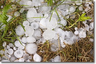
Weather Topic: What is Hail?
Home - Education - Precipitation - Hail
 Next Topic: Hole Punch Clouds
Hail is a form of precipitation which is recognized by large solid balls or
clumps of ice. Hail is created by thunderstorm clouds with strong updrafts of wind.
As the hailstones remain in the updraft, ice is deposited onto them until their
weight becomes heavy enough for them to fall to the earth's surface.
Hail storms can cause significant damage to crops, aircrafts, and man-made structures,
despite the fact that the duration is usually less than ten minutes.
Next Topic: Hole Punch Clouds
Weather Topic: What are Mammatus Clouds?
Home - Education - Cloud Types - Mammatus Clouds
 Next Topic: Nimbostratus Clouds
A mammatus cloud is a cloud with a unique feature which resembles
a web of pouches hanging along the base of the cloud.
In the United States, mammatus clouds tend to form in the warmer months, commonly
in the Midwest and eastern regions.
While they usually form at the bottom of a cumulonimbis cloud, they can also form
under altostratus, altocumulus, stratocumulus, and cirrus clouds. Mammatus clouds
warn that severe weather is close.
Next Topic: Nimbostratus Clouds
Current conditions powered by WeatherAPI.com


