Weather Alert in Ohio
Flood Warning issued April 4 at 11:02AM EDT until April 4 at 11:00PM EDT by NWS Cleveland OH
AREAS AFFECTED: Ashland, OH; Crawford, OH; Holmes, OH; Knox, OH; Marion, OH; Morrow, OH; Richland, OH
DESCRIPTION: * WHAT...Small stream flooding caused by excessive rainfall is expected. * WHERE...Portions of north central and northeast Ohio, including the following counties, in north central Ohio, Ashland, Crawford, Knox, Marion, Morrow and Richland. In northeast Ohio, Holmes. * WHEN...Until 1100 PM EDT Saturday. * IMPACTS...Flooding of rivers, creeks, streams, and other low-lying and flood-prone locations is occurring. Numerous roads remain closed due to flooding. Streams continue to rise due to excess runoff from earlier rainfall. * ADDITIONAL DETAILS... - At 1053 AM EDT, Doppler radar and automated rain gauges indicated heavy rain due to thunderstorms last evening. Flooding is already occurring in the warned area. Between 2.5 and 4.5 inches of rain have fallen. - Additional rainfall amounts up to 1 inch are possible in the warned area this afternoon and evening with another round of showers and thunderstorms. - Some locations that will experience flooding include... Mansfield, Marion, Mount Gilead, Galion, Ontario, Lexington, Crestline, Loudonville, Fredericktown, Cardington, Bellville, Hayesville, Glenmont, Chesterville, Nashville, Waterford, Butler, Perrysville, Lucas and Caledonia. - Flooding is ongoing for several area rivers and creeks. Flooding has been reported on the Clear Fork of the Mohican River near Butler, the Black Fork of the Mohican River near Loudonville and near Charles Mill Lake, and Whetstone Creek near Mount Gilead. - Please visit www.weather.gov/safety/flood for flood safety and preparedness information.
INSTRUCTION: Turn around, don't drown when encountering flooded roads. Most flood deaths occur in vehicles. Stay away or be swept away. River banks and culverts can become unstable and unsafe.
Want more detail? Get the Complete 7 Day and Night Detailed Forecast!
Current U.S. National Radar--Current
The Current National Weather Radar is shown below with a UTC Time (subtract 5 hours from UTC to get Eastern Time).

National Weather Forecast--Current
The Current National Weather Forecast and National Weather Map are shown below.

National Weather Forecast for Tomorrow
Tomorrow National Weather Forecast and Tomorrow National Weather Map are show below.

North America Water Vapor (Moisture)
This map shows recent moisture content over North America. Bright and colored areas show high moisture (ie, clouds); brown indicates very little moisture present; black indicates no moisture.

Weather Topic: What is Snow?
Home - Education - Precipitation - Snow
 Next Topic: Stratocumulus Clouds
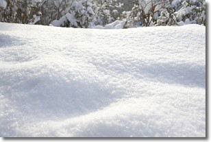
Snow is precipitation taking the form of ice crystals. Each ice crystal, or snowflake,
has unique characteristics, but all of them grow in a hexagonal structure.
Snowfall can last for sustained periods of time and result in significant buildup
of snow on the ground.
On the earth's surface, snow starts out light and powdery, but as it begins to melt
it tends to become more granular, producing small bits of ice which have the consistency of
sand. After several cycles of melting and freezing, snow can become very dense
and ice-like, commonly known as snow pack.
Next Topic: Stratocumulus Clouds
Weather Topic: What are Stratus Clouds?
Home - Education - Cloud Types - Stratus Clouds
 Next Topic: Wall Clouds
Stratus clouds are similar to altostratus clouds, but form at a
lower altitude and are identified by their fog-like appearance, lacking the
distinguishing features of most clouds.
Stratus clouds are wider than most clouds, and their base has a smooth, uniform
look which is lighter in color than a nimbostratus cloud.
The presence of a stratus cloud indicates the possibility of minor precipitation,
such as drizzle, but heavier precipitation does not typically arrive in the form
of a stratus cloud.
Next Topic: Wall Clouds
Current conditions powered by WeatherAPI.com


