Weather Alert in New York
Winter Storm Warning issued February 22 at 5:07AM EST until February 23 at 7:00PM EST by NWS Albany NY
AREAS AFFECTED: Schoharie; Western Schenectady; Eastern Schenectady; Western Albany; Eastern Albany; Western Rensselaer; Eastern Rensselaer; Bennington; Western Windham; Eastern Windham
DESCRIPTION: * WHAT...Heavy snow expected. Total snow accumulations between 5 and 12 inches with locally higher amounts into the Helderbergs and Schoharie County. Winds gusting between 30 and 40 mph will lead to areas of blowing snow. * WHERE...Schoharie County, the Helderbergs, portions of the Capital District and the Rensselaer Plateau in eastern New York and all of southern Vermont. * WHEN...From 7 PM this evening to 7 PM EST Monday. * IMPACTS...Travel could be difficult. Visibilities may drop below 1/4 mile due to falling and blowing snow. Areas of blowing snow could significantly reduce visibility. The hazardous conditions could impact the Monday morning and evening commutes. * ADDITIONAL DETAILS...A powerful nor'easter will impact the region late this afternoon through Monday. The higher snowfall amounts will be favored across the higher elevations. Snowfall rates may reach 1 inch per hour at times tonight into early Monday morning with up to 2 inches in the Helderbergs and Schoharie County.
INSTRUCTION: If you must travel, keep an extra flashlight, food, and water in your vehicle in case of an emergency.
Want more detail? Get the Complete 7 Day and Night Detailed Forecast!
Current U.S. National Radar--Current
The Current National Weather Radar is shown below with a UTC Time (subtract 5 hours from UTC to get Eastern Time).

National Weather Forecast--Current
The Current National Weather Forecast and National Weather Map are shown below.

National Weather Forecast for Tomorrow
Tomorrow National Weather Forecast and Tomorrow National Weather Map are show below.

North America Water Vapor (Moisture)
This map shows recent moisture content over North America. Bright and colored areas show high moisture (ie, clouds); brown indicates very little moisture present; black indicates no moisture.

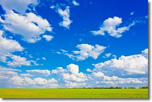
Weather Topic: What are Cumulus Clouds?
Home - Education - Cloud Types - Cumulus Clouds
 Next Topic: Drizzle
Cumulus clouds are fluffy and textured with rounded tops, and
may have flat bottoms. The border of a cumulus cloud
is clearly defined, and can have the appearance of cotton or cauliflower.
Cumulus clouds form at low altitudes (rarely above 2 km) but can grow very tall,
becoming cumulus congestus and possibly the even taller cumulonimbus clouds.
When cumulus clouds become taller, they have a greater chance of producing precipitation.
Next Topic: Drizzle
Weather Topic: What is Evaporation?
Home - Education - Precipitation - Evaporation
 Next Topic: Fog
Evaporation is the process which returns water from the earth
back to the atmosphere, and is another crucial process in the water cycle.
Evaporation is the transformation of liquid into gas, and it happens because
molecules are excited by the application of energy and turn into vapor.
In order for water to evaporate it has to be on the surface of a body of water.
Next Topic: Fog
Current conditions powered by WeatherAPI.com


