Weather Alert in Wyoming
Winter Weather Advisory issued February 15 at 10:43AM MST until February 17 at 5:00PM MST by NWS Riverton WY
AREAS AFFECTED: Yellowstone National Park
DESCRIPTION: * WHAT...Snow expected. Total snow accumulations between 3 and 6 inches across much of the area, with higher amounts 7 to 11 inches over Pitchstone Plateau of southwest Yellowstone. Accumulations up to 2 inches around Mammoth. Winds gusting as high as 45 mph. * WHERE...Yellowstone National Park. * WHEN...From 11 PM Monday to 5 PM MST Tuesday. * IMPACTS...Backcountry travel will be difficult.
INSTRUCTION: Slow down and use caution while traveling. For graphical depictions of the snowfall forecast, including the official NWS forecast, high end amounts, and low end amounts, visit https://weather.gov/riw/winter. For winter road conditions from the Wyoming Department of Transportation, visit https://wyoroad.info.
Want more detail? Get the Complete 7 Day and Night Detailed Forecast!
Current U.S. National Radar--Current
The Current National Weather Radar is shown below with a UTC Time (subtract 5 hours from UTC to get Eastern Time).

National Weather Forecast--Current
The Current National Weather Forecast and National Weather Map are shown below.

National Weather Forecast for Tomorrow
Tomorrow National Weather Forecast and Tomorrow National Weather Map are show below.

North America Water Vapor (Moisture)
This map shows recent moisture content over North America. Bright and colored areas show high moisture (ie, clouds); brown indicates very little moisture present; black indicates no moisture.

Weather Topic: What is Fog?
Home - Education - Cloud Types - Fog
 Next Topic: Fractus Clouds
Fog is technically a type of stratus cloud, which lies along the
ground and obscures visibility.
It is usually created when humidity in the air condenses into tiny water droplets.
Because of this, some places are more prone to foggy weather, such as regions
close to a body of water.
Fog is similar to mist; both are the appearance of water droplets suspended in
the air, but fog is the term applied to the condition when visibility is less than 1 km.
Next Topic: Fractus Clouds
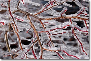
Weather Topic: What is Freezing Rain?
Home - Education - Precipitation - Freezing Rain
 Next Topic: Graupel
Freezing rain is a condition where precipitation which has fallen in the form of
water droplets reaches temperatures which are below freezing and freezes upon
coming into contact
with surface objects. The result of this precipitation is a glaze of ice which
can be damaging to plants and man-made structures. A severe onset of freezing
rain which results in a very thick glaze of ice is known as an ice storm.
Next Topic: Graupel
Current conditions powered by WeatherAPI.com


