Weather Alert in Kansas
Flood Warning issued September 10 at 6:49PM CDT until September 13 at 3:00PM CDT by NWS Topeka KS
AREAS AFFECTED: Ottawa, KS
DESCRIPTION: ...The Flood Warning continues for the following rivers in Kansas... Salt Creek near Ada affecting Ottawa County. * WHAT...Moderate flooding is occurring and moderate flooding is forecast. This approaches the flood of record. * WHERE...Salt Creek near Ada. * WHEN...Until Saturday afternoon. * IMPACTS...At 18.0 feet, Minor low land flooding along the Salt Creek. At 20.0 feet, 50th Road just south of the bridge over the Salt Creek floods. At 20.2 feet, Deck of 50th Road bridge over the Salt Creek floods. At 21.0 feet, Flood waters are over one half mile wide over cultivated farm land 3 miles east southeast of the town of Ada. * ADDITIONAL DETAILS... - At 5:45 PM CDT Wednesday the stage was 21.7 feet. - Forecast...The river is expected to fall below flood stage early Saturday morning and continue falling to 14.5 feet early Monday afternoon. - Flood stage is 18.0 feet.
INSTRUCTION: Motorists should not attempt to drive around barricades or drive cars through flooded areas. This product along with additional weather and stream information is available at www.weather.gov/top/.
Want more detail? Get the Complete 7 Day and Night Detailed Forecast!
Current U.S. National Radar--Current
The Current National Weather Radar is shown below with a UTC Time (subtract 5 hours from UTC to get Eastern Time).

National Weather Forecast--Current
The Current National Weather Forecast and National Weather Map are shown below.

National Weather Forecast for Tomorrow
Tomorrow National Weather Forecast and Tomorrow National Weather Map are show below.

North America Water Vapor (Moisture)
This map shows recent moisture content over North America. Bright and colored areas show high moisture (ie, clouds); brown indicates very little moisture present; black indicates no moisture.

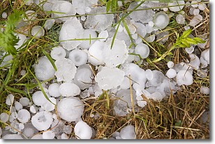
Weather Topic: What is Hail?
Home - Education - Precipitation - Hail
 Next Topic: Hole Punch Clouds
Hail is a form of precipitation which is recognized by large solid balls or
clumps of ice. Hail is created by thunderstorm clouds with strong updrafts of wind.
As the hailstones remain in the updraft, ice is deposited onto them until their
weight becomes heavy enough for them to fall to the earth's surface.
Hail storms can cause significant damage to crops, aircrafts, and man-made structures,
despite the fact that the duration is usually less than ten minutes.
Next Topic: Hole Punch Clouds
Weather Topic: What are Mammatus Clouds?
Home - Education - Cloud Types - Mammatus Clouds
 Next Topic: Nimbostratus Clouds
A mammatus cloud is a cloud with a unique feature which resembles
a web of pouches hanging along the base of the cloud.
In the United States, mammatus clouds tend to form in the warmer months, commonly
in the Midwest and eastern regions.
While they usually form at the bottom of a cumulonimbis cloud, they can also form
under altostratus, altocumulus, stratocumulus, and cirrus clouds. Mammatus clouds
warn that severe weather is close.
Next Topic: Nimbostratus Clouds
Current conditions powered by WeatherAPI.com


