Weather Alert in Michigan
Flood Watch issued April 4 at 11:34AM EDT until April 9 at 8:00PM EDT by NWS Grand Rapids MI
AREAS AFFECTED: Kent
DESCRIPTION: ...The National Weather Service in Grand Rapids MI has issued a Flood Watch for the following rivers in Michigan... Grand River at Ionia affecting Ionia County. Grand River at Ada affecting Kent County. Grand River at Grand Rapids affecting Kent County. ...Forecast flooding changed from Minor to Moderate severity and increased in duration for the following rivers in Michigan... Grand River at Robinson Township affecting Ottawa County. ...The Flood Watch is replaced by a River Flood Warning for the following rivers in Michigan... Muskegon River at Bridgeton affecting Newaygo County. * WHAT...Flooding is possible. * WHERE...Grand River at Grand Rapids. * WHEN...From Tuesday afternoon to Thursday evening. * IMPACTS...At 18.0 feet, Expect minor flooding of basements in low lying areas in Grand Rapids. Moderate flooding of homes and structures occurs upstream at Comstock Park and downstream in Robinson Township. * ADDITIONAL DETAILS... - At 10:00 AM EDT Saturday the stage was 10.1 feet. - Forecast...Flood stage may be reached early Tuesday afternoon. - Flood stage is 18.0 feet. - http://www.weather.gov/safety/flood
INSTRUCTION: Residents and those with interests near the river should monitor rising water levels and be prepared for possible flood warnings. Stay tuned to further developments by listening to your local radio, television, or NOAA Weather Radio for further information. Additional information is available at www.weather.gov/grr.
Want more detail? Get the Complete 7 Day and Night Detailed Forecast!
Current U.S. National Radar--Current
The Current National Weather Radar is shown below with a UTC Time (subtract 5 hours from UTC to get Eastern Time).

National Weather Forecast--Current
The Current National Weather Forecast and National Weather Map are shown below.

National Weather Forecast for Tomorrow
Tomorrow National Weather Forecast and Tomorrow National Weather Map are show below.

North America Water Vapor (Moisture)
This map shows recent moisture content over North America. Bright and colored areas show high moisture (ie, clouds); brown indicates very little moisture present; black indicates no moisture.

Weather Topic: What are Fractus Clouds?
Home - Education - Cloud Types - Fractus Clouds
 Next Topic: Freezing Rain
A fractus cloud (scud) is a fragmented, tattered cloud which has
likely been sheared off of another cloud. They are accessory clouds, meaning they
develop from parent clouds, and are named in a way which describes the original
cloud which contained them.
Fractus clouds which have originated from cumulus clouds are referred to as
cumulus fractus, while fractus clouds which have originated from stratus clouds
are referred to as stratus fractus. Under certain conditions a fractus cloud might
merge with another cloud, or develop into a cumulus cloud, but usually a
fractus cloud seen by itself will dissipate rapidly.
They are often observed on the leading and trailing edges of storm clouds,
and are a display of wind activity.
Next Topic: Freezing Rain
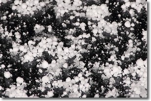
Weather Topic: What is Graupel?
Home - Education - Precipitation - Graupel
 Next Topic: Hail
Graupel is a form of precipitation that is created by atmospheric conditions
which cause supercooled water droplets to contact snow crystals and freeze to
their surface.
Sometimes known as soft hail or snow pellets, graupel is delicate and easily
destroyed by touch. Whereas hail usually falls during severe weather, graupel
doesn't require such conditions to form, and can form in mild precipitation
similar to situations which produce snowfall.
Next Topic: Hail
Current conditions powered by WeatherAPI.com


