Weather Alert in Ohio
Flood Warning issued April 3 at 3:41PM EDT until April 4 at 2:00AM EDT by NWS Cleveland OH
AREAS AFFECTED: Seneca, OH
DESCRIPTION: ...The Flood Warning continues for the following rivers in Ohio... Portage River At Woodville affecting Wood and Sandusky Counties. Maumee River At Waterville affecting Lucas and Wood Counties. ...The Flood Warning is extended for the following rivers in Ohio... Sandusky River At Tiffin affecting Seneca County. Killbuck Creek Near Killbuck affecting Wayne and Holmes Counties. ...The Flood Warning is cancelled for the following rivers in Ohio... Black River At Elyria affecting Lorain County. For the Portage River...including Woodville...Moderate flooding is forecast. For the Sandusky River...including Upper Sandusky, Fremont, Tiffin, Bucyrus...Minor flooding is forecast. For the Maumee River...including Grand Rapids, Waterville...Minor flooding is forecast. For the Killbuck Creek...including Killbuck...Minor flooding is forecast. * WHAT...Minor flooding is occurring and minor flooding is forecast. * WHERE...Sandusky River at Tiffin. * WHEN...Until just after midnight tonight. * IMPACTS...At 9.0 feet, Lowland flooding occurs north and south of the floodwall in Tiffin. Coe Street, Water Street, East Davis Street, and riverside property along Front Street are threatened. * ADDITIONAL DETAILS... - At 2:45 PM EDT Friday the stage was 9.3 feet. - Forecast...The river is expected to fall below flood stage this evening and continue falling to 5.8 feet early Wednesday afternoon. - Flood stage is 9.0 feet. - Flood History...This crest compares to a previous crest of 9.3 feet on 05/27/2011. - Please visit www.weather.gov/safety/flood for flood safety and preparedness information.
INSTRUCTION: Turn around, don't drown when encountering flooded roads. Most flood deaths occur in vehicles. Additional information is available at www.weather.gov/cle. The next statement will be issued this afternoon at 445 PM EDT.
Want more detail? Get the Complete 7 Day and Night Detailed Forecast!
Current U.S. National Radar--Current
The Current National Weather Radar is shown below with a UTC Time (subtract 5 hours from UTC to get Eastern Time).

National Weather Forecast--Current
The Current National Weather Forecast and National Weather Map are shown below.

National Weather Forecast for Tomorrow
Tomorrow National Weather Forecast and Tomorrow National Weather Map are show below.

North America Water Vapor (Moisture)
This map shows recent moisture content over North America. Bright and colored areas show high moisture (ie, clouds); brown indicates very little moisture present; black indicates no moisture.

Weather Topic: What are Shelf Clouds?
Home - Education - Cloud Types - Shelf Clouds
 Next Topic: Sleet
A shelf cloud is similar to a wall cloud, but forms at the front
of a storm cloud, instead of at the rear, where wall clouds form.
A shelf cloud is caused by a series of events set into motion by the advancing
storm; first, cool air settles along the ground where precipitation has just fallen.
As the cool air is brought in, the warmer air is displaced, and rises above it,
because it is less dense. When the warmer air reaches the bottom of the storm cloud,
it begins to cool again, and the resulting condensation is a visible shelf cloud.
Next Topic: Sleet
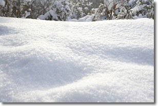
Weather Topic: What is Snow?
Home - Education - Precipitation - Snow
 Next Topic: Stratocumulus Clouds
Snow is precipitation taking the form of ice crystals. Each ice crystal, or snowflake,
has unique characteristics, but all of them grow in a hexagonal structure.
Snowfall can last for sustained periods of time and result in significant buildup
of snow on the ground.
On the earth's surface, snow starts out light and powdery, but as it begins to melt
it tends to become more granular, producing small bits of ice which have the consistency of
sand. After several cycles of melting and freezing, snow can become very dense
and ice-like, commonly known as snow pack.
Next Topic: Stratocumulus Clouds
Current conditions powered by WeatherAPI.com


