Weather Alert in Alaska
Hydrologic Outlook issued August 30 at 9:40PM AKDT by NWS Fairbanks AK
AREAS AFFECTED: Fairbanks Metro Area
DESCRIPTION: ESFAFG As of 9 PM on Saturday, the Tanana River at Fairbanks has risen to 23.74 feet and water levels are still rising. Flooding impacts are not expected at this time, but those near the Tanana River outside of the dike may observe high groundwater levels. While it is still somewhat uncertain exactly how much the Tanana will rise before cresting and receding, river levels will likely approach 24 feet either tomorrow or Labor Day. At this level, while no specific flood impacts will be realized, bankfull conditions will be noted in the vicinity of Old Richardson Hwy in Salcha, and water may begin to spill over the bank and approach Ruger Trail near Bradbury Road. Tanana River water has a history of beginning to flow into the Piledriver Slough as well when river levels in the Tanana at Fairbanks reach 24 feet. Additional rainfall amounts over the next few days in Fairbanks and upstream areas are expected to remain under a quarter of an inch. As such, any further rainfall this weekend is not expected to bring additional impacts to locations in Fairbanks near the Tanana.
INSTRUCTION: N/A
Want more detail? Get the Complete 7 Day and Night Detailed Forecast!
Current U.S. National Radar--Current
The Current National Weather Radar is shown below with a UTC Time (subtract 5 hours from UTC to get Eastern Time).

National Weather Forecast--Current
The Current National Weather Forecast and National Weather Map are shown below.

National Weather Forecast for Tomorrow
Tomorrow National Weather Forecast and Tomorrow National Weather Map are show below.

North America Water Vapor (Moisture)
This map shows recent moisture content over North America. Bright and colored areas show high moisture (ie, clouds); brown indicates very little moisture present; black indicates no moisture.

Weather Topic: What are Fractus Clouds?
Home - Education - Cloud Types - Fractus Clouds
 Next Topic: Freezing Rain
A fractus cloud (scud) is a fragmented, tattered cloud which has
likely been sheared off of another cloud. They are accessory clouds, meaning they
develop from parent clouds, and are named in a way which describes the original
cloud which contained them.
Fractus clouds which have originated from cumulus clouds are referred to as
cumulus fractus, while fractus clouds which have originated from stratus clouds
are referred to as stratus fractus. Under certain conditions a fractus cloud might
merge with another cloud, or develop into a cumulus cloud, but usually a
fractus cloud seen by itself will dissipate rapidly.
They are often observed on the leading and trailing edges of storm clouds,
and are a display of wind activity.
Next Topic: Freezing Rain
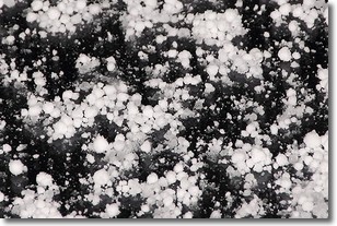
Weather Topic: What is Graupel?
Home - Education - Precipitation - Graupel
 Next Topic: Hail
Graupel is a form of precipitation that is created by atmospheric conditions
which cause supercooled water droplets to contact snow crystals and freeze to
their surface.
Sometimes known as soft hail or snow pellets, graupel is delicate and easily
destroyed by touch. Whereas hail usually falls during severe weather, graupel
doesn't require such conditions to form, and can form in mild precipitation
similar to situations which produce snowfall.
Next Topic: Hail
Current conditions powered by WeatherAPI.com


