Weather Alert in Nebraska
High Wind Warning issued March 12 at 5:25PM MDT until March 12 at 9:00PM MDT by NWS Cheyenne WY
AREAS AFFECTED: Dawes; Box Butte; Scotts Bluff; Banner; Morrill; Kimball; Cheyenne; North Sioux; South Sioux
DESCRIPTION: * WHAT...West winds 35 to 45 mph with gusts up to 75 mph expected and reduced visibility in blowing dust. * WHERE...Banner County, Box Butte County, Cheyenne County, Dawes County, Kimball County, Morrill County, Northern Sioux County, Scotts Bluff County, and Southern Sioux County. * WHEN...For the Blowing Dust Advisory, until 8 PM MDT this evening. For the High Wind Warning, until 9 PM MDT this evening. * IMPACTS...Mainly to transportation. Strong cross winds will be hazardous to light weight or high profile vehicles, including campers and tractor trailers. * ADDITIONAL DETAILS...Areas of blowing dust could lead to reduced visibility. The strong winds will lead to fire weather concerns and control problems if fires do start.
INSTRUCTION: Persons with respiratory problems should make preparations to stay indoors until the storm passes. Be ready for a sudden drop in visibility to near zero. If you encounter blowing dust or blowing sand on the roadway or see it approaching, pull off the road as far as possible and put your vehicle in park. Turn the lights all the way off and keep foot off the brake pedal. Remember, 'Pull Aside, Stay Alive'. A High Wind Warning means a hazardous high wind event is expected or occurring. Sustained wind speeds of at least 40 MPH or gusts of 58 MPH or stronger can lead to property damage.
Want more detail? Get the Complete 7 Day and Night Detailed Forecast!
Current U.S. National Radar--Current
The Current National Weather Radar is shown below with a UTC Time (subtract 5 hours from UTC to get Eastern Time).

National Weather Forecast--Current
The Current National Weather Forecast and National Weather Map are shown below.

National Weather Forecast for Tomorrow
Tomorrow National Weather Forecast and Tomorrow National Weather Map are show below.

North America Water Vapor (Moisture)
This map shows recent moisture content over North America. Bright and colored areas show high moisture (ie, clouds); brown indicates very little moisture present; black indicates no moisture.

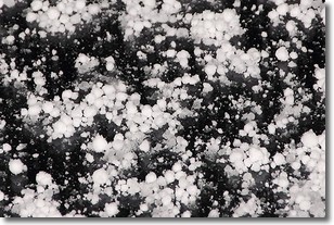
Weather Topic: What is Graupel?
Home - Education - Precipitation - Graupel
 Next Topic: Hail
Graupel is a form of precipitation that is created by atmospheric conditions
which cause supercooled water droplets to contact snow crystals and freeze to
their surface.
Sometimes known as soft hail or snow pellets, graupel is delicate and easily
destroyed by touch. Whereas hail usually falls during severe weather, graupel
doesn't require such conditions to form, and can form in mild precipitation
similar to situations which produce snowfall.
Next Topic: Hail
Weather Topic: What are Hole Punch Clouds?
Home - Education - Cloud Types - Hole Punch Clouds
 Next Topic: Mammatus Clouds
A hole punch cloud is an unusual occurrence when a disk-shaped
hole appears in a cirrostratus, cirrocumulus, or altocumulus cloud.
When part of the cloud forms ice crystals, water droplets in the surrounding area
of the cloud evaporate. The effect of this process produces a large elliptical
gap in the cloud. The hole punch cloud formation is rare, but it is not specific
to any geographic area.
Other names which have been used to describe this phenomena include fallstreak hole,
skypunch, and cloud hole.
Next Topic: Mammatus Clouds
Current conditions powered by WeatherAPI.com


