Weather Alert in California
Flood Watch issued September 1 at 12:24PM PDT until September 3 at 11:00PM PDT by NWS Los Angeles/Oxnard CA
AREAS AFFECTED: Western San Gabriel Mountains and Highway 14 Corridor; Eastern San Gabriel Mountains; Western Antelope Valley Foothills; Eastern Antelope Valley Foothills; Antelope Valley
DESCRIPTION: * WHAT...Flooding caused by excessive rainfall is possible. * WHERE...Northeastern Los Angeles County, including the following areas, Bridge Fire Burn Scar, Antelope Valley, Antelope Valley Foothills, San Gabriel Mountains, and Highway 14 Corridor. * WHEN...From late Tuesday morning through Wednesday evening. * IMPACTS...Flooding from thunderstorms and showers may occur in poor drainage and urban areas. Peak rain rates may reach 0.5 to 1.0 inch per hour. * ADDITIONAL DETAILS... - Increasing moisture and instability combined with slow moving storms will pose an increased risk of flash flooding. Strong outflow winds will be possible with thunderstorms, with locally damaging gusts to 60 mph possible. - http://www.weather.gov/safety/flood
INSTRUCTION: You should monitor later forecasts and be alert for possible Flood Warnings. Those living in areas prone to flooding should be prepared to take action should flooding develop.
Want more detail? Get the Complete 7 Day and Night Detailed Forecast!
Current U.S. National Radar--Current
The Current National Weather Radar is shown below with a UTC Time (subtract 5 hours from UTC to get Eastern Time).

National Weather Forecast--Current
The Current National Weather Forecast and National Weather Map are shown below.

National Weather Forecast for Tomorrow
Tomorrow National Weather Forecast and Tomorrow National Weather Map are show below.

North America Water Vapor (Moisture)
This map shows recent moisture content over North America. Bright and colored areas show high moisture (ie, clouds); brown indicates very little moisture present; black indicates no moisture.

Weather Topic: What is Fog?
Home - Education - Cloud Types - Fog
 Next Topic: Fractus Clouds
Fog is technically a type of stratus cloud, which lies along the
ground and obscures visibility.
It is usually created when humidity in the air condenses into tiny water droplets.
Because of this, some places are more prone to foggy weather, such as regions
close to a body of water.
Fog is similar to mist; both are the appearance of water droplets suspended in
the air, but fog is the term applied to the condition when visibility is less than 1 km.
Next Topic: Fractus Clouds
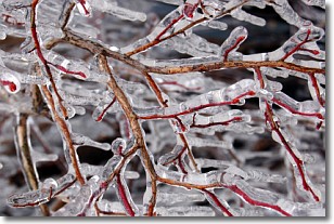
Weather Topic: What is Freezing Rain?
Home - Education - Precipitation - Freezing Rain
 Next Topic: Graupel
Freezing rain is a condition where precipitation which has fallen in the form of
water droplets reaches temperatures which are below freezing and freezes upon
coming into contact
with surface objects. The result of this precipitation is a glaze of ice which
can be damaging to plants and man-made structures. A severe onset of freezing
rain which results in a very thick glaze of ice is known as an ice storm.
Next Topic: Graupel
Current conditions powered by WeatherAPI.com


