Weather Alert in Wisconsin
Winter Storm Watch issued March 14 at 5:40AM CDT until March 16 at 7:00PM CDT by NWS Milwaukee/Sullivan WI
AREAS AFFECTED: Iowa; Dane; Jefferson; Waukesha; Milwaukee; Lafayette; Green; Rock; Walworth; Racine; Kenosha
DESCRIPTION: ...WINTER STORM BEGINS TONIGHT AND CONTINUES THROUGH MONDAY... .A strong late winter storm system is expected to impact southern Wisconsin during the last half of the weekend in 3 phases: Saturday night into Sunday morning expecting snow accumulations of 1 to 3 inches and the potential for around a tenth of an inch of ice accumulation. Sunday late morning into Sunday afternoon will see milder temps and mostly rain with a few thunderstorms. Late Sunday evening through Monday expect heavy banded snow to impact southern WI with snowfall totals from 5 to 9 inches with locally higher amounts possible. Wind gusts up to 45 mph will cause blowing snow and visibility restrictions. Hazardous travel is expected during both headline time frames. * WHAT...Heavy snow possible. Total snow accumulations between 4 and 7 inches possible. A light glaze of ice may occur. Winds could gust as high as 45 mph causing blowing snow and visibility restrictions. * WHERE...Portions of south central and southeast Wisconsin. * WHEN...From Sunday afternoon through Monday evening. * IMPACTS...Visibilities may drop below 1/4 mile due to falling and blowing snow. The strong winds and weight of snow on tree limbs may down power lines and could cause sporadic power outages. Travel could be very difficult. The hazardous conditions could impact the Monday morning and evening commutes. Gusty winds could bring down tree branches.
INSTRUCTION: Monitor the latest forecasts for updates on this situation.
Want more detail? Get the Complete 7 Day and Night Detailed Forecast!
Current U.S. National Radar--Current
The Current National Weather Radar is shown below with a UTC Time (subtract 5 hours from UTC to get Eastern Time).

National Weather Forecast--Current
The Current National Weather Forecast and National Weather Map are shown below.

National Weather Forecast for Tomorrow
Tomorrow National Weather Forecast and Tomorrow National Weather Map are show below.

North America Water Vapor (Moisture)
This map shows recent moisture content over North America. Bright and colored areas show high moisture (ie, clouds); brown indicates very little moisture present; black indicates no moisture.

Weather Topic: What is Freezing Rain?
Home - Education - Precipitation - Freezing Rain
 Next Topic: Graupel
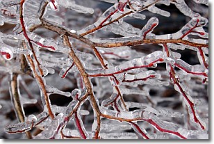
Freezing rain is a condition where precipitation which has fallen in the form of
water droplets reaches temperatures which are below freezing and freezes upon
coming into contact
with surface objects. The result of this precipitation is a glaze of ice which
can be damaging to plants and man-made structures. A severe onset of freezing
rain which results in a very thick glaze of ice is known as an ice storm.
Next Topic: Graupel
Weather Topic: What is Hail?
Home - Education - Precipitation - Hail
 Next Topic: Hole Punch Clouds
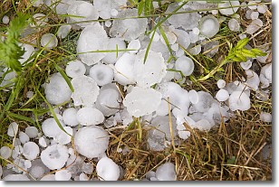
Hail is a form of precipitation which is recognized by large solid balls or
clumps of ice. Hail is created by thunderstorm clouds with strong updrafts of wind.
As the hailstones remain in the updraft, ice is deposited onto them until their
weight becomes heavy enough for them to fall to the earth's surface.
Hail storms can cause significant damage to crops, aircrafts, and man-made structures,
despite the fact that the duration is usually less than ten minutes.
Next Topic: Hole Punch Clouds
Current conditions powered by WeatherAPI.com


