Weather Alert in Alaska
Special Weather Statement issued August 27 at 1:39PM AKDT by NWS Anchorage AK
AREAS AFFECTED: Lower Matanuska Valley
DESCRIPTION: A frontal system moving into Southcentral will usher strong and gusty winds into the Matanuska Valley starting late on Thursday morning, including in and around the Alaska State Fairgrounds. The strongest wind gusts will range from around 30 mph to near 50 mph, with the strongest gusts focused near Palmer and Butte during the afternoon hours on Thursday. Winds will begin to diminish by late Thursday evening into early Friday morning as the front pushes to the east. People are urged to secure loose objects that could be blown around by the strong winds and use caution while traveling. Winds could coincide with periods of moderate rain, potentially making driving difficult at times. Trees are still fully leafed and will be unusually vulnerable to damage from the strong winds. Localized power outages will be possible due the potential for strong winds to bring down tree branches onto power lines.
INSTRUCTION: N/A
Want more detail? Get the Complete 7 Day and Night Detailed Forecast!
Current U.S. National Radar--Current
The Current National Weather Radar is shown below with a UTC Time (subtract 5 hours from UTC to get Eastern Time).

National Weather Forecast--Current
The Current National Weather Forecast and National Weather Map are shown below.

National Weather Forecast for Tomorrow
Tomorrow National Weather Forecast and Tomorrow National Weather Map are show below.

North America Water Vapor (Moisture)
This map shows recent moisture content over North America. Bright and colored areas show high moisture (ie, clouds); brown indicates very little moisture present; black indicates no moisture.

Weather Topic: What is Fog?
Home - Education - Cloud Types - Fog
 Next Topic: Fractus Clouds
Fog is technically a type of stratus cloud, which lies along the
ground and obscures visibility.
It is usually created when humidity in the air condenses into tiny water droplets.
Because of this, some places are more prone to foggy weather, such as regions
close to a body of water.
Fog is similar to mist; both are the appearance of water droplets suspended in
the air, but fog is the term applied to the condition when visibility is less than 1 km.
Next Topic: Fractus Clouds
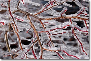
Weather Topic: What is Freezing Rain?
Home - Education - Precipitation - Freezing Rain
 Next Topic: Graupel
Freezing rain is a condition where precipitation which has fallen in the form of
water droplets reaches temperatures which are below freezing and freezes upon
coming into contact
with surface objects. The result of this precipitation is a glaze of ice which
can be damaging to plants and man-made structures. A severe onset of freezing
rain which results in a very thick glaze of ice is known as an ice storm.
Next Topic: Graupel
Current conditions powered by WeatherAPI.com


