Weather Alert in Arizona
Severe Thunderstorm Warning issued August 25 at 5:27PM MST until August 25 at 6:15PM MST by NWS Phoenix AZ
AREAS AFFECTED: Maricopa, AZ
DESCRIPTION: SVRPSR The National Weather Service in Phoenix has issued a * Severe Thunderstorm Warning for... Maricopa County in south central Arizona... * Until 615 PM MST. * At 526 PM MST, a severe thunderstorm was located over Queen Creek, or 7 miles southeast of Gilbert, moving northwest at 15 mph. HAZARD...60 mph wind gusts. SOURCE...Radar indicated. IMPACT...Expect damage to roofs, siding, and trees. * Locations impacted include... Mesa, Chandler, Gilbert, Tempe, Gilbert City Hall, Downtown Mesa, Tumbleweed Park, Chandler City Hall, San Tan Village Mall, Freestone Park, Fiesta Mall, Phoenix Mesa Gateway Airport, and Higley. This includes the following highways... US Highway 60 between mile markers 178 and 188. AZ Route 87 between mile markers 164 and 173. AZ Route 202 between mile markers 35 and 49.
INSTRUCTION: For your protection move to an interior room on the lowest floor of a building.
Want more detail? Get the Complete 7 Day and Night Detailed Forecast!
Current U.S. National Radar--Current
The Current National Weather Radar is shown below with a UTC Time (subtract 5 hours from UTC to get Eastern Time).

National Weather Forecast--Current
The Current National Weather Forecast and National Weather Map are shown below.

National Weather Forecast for Tomorrow
Tomorrow National Weather Forecast and Tomorrow National Weather Map are show below.

North America Water Vapor (Moisture)
This map shows recent moisture content over North America. Bright and colored areas show high moisture (ie, clouds); brown indicates very little moisture present; black indicates no moisture.

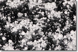
Weather Topic: What is Graupel?
Home - Education - Precipitation - Graupel
 Next Topic: Hail
Graupel is a form of precipitation that is created by atmospheric conditions
which cause supercooled water droplets to contact snow crystals and freeze to
their surface.
Sometimes known as soft hail or snow pellets, graupel is delicate and easily
destroyed by touch. Whereas hail usually falls during severe weather, graupel
doesn't require such conditions to form, and can form in mild precipitation
similar to situations which produce snowfall.
Next Topic: Hail
Weather Topic: What are Hole Punch Clouds?
Home - Education - Cloud Types - Hole Punch Clouds
 Next Topic: Mammatus Clouds
A hole punch cloud is an unusual occurrence when a disk-shaped
hole appears in a cirrostratus, cirrocumulus, or altocumulus cloud.
When part of the cloud forms ice crystals, water droplets in the surrounding area
of the cloud evaporate. The effect of this process produces a large elliptical
gap in the cloud. The hole punch cloud formation is rare, but it is not specific
to any geographic area.
Other names which have been used to describe this phenomena include fallstreak hole,
skypunch, and cloud hole.
Next Topic: Mammatus Clouds
Current conditions powered by WeatherAPI.com


