Weather Alert in Alaska
Flood Advisory issued September 1 at 9:32PM AKDT until September 2 at 10:15AM AKDT by NWS Fairbanks AK
AREAS AFFECTED: Central Interior
DESCRIPTION: * WHAT...Flooding caused by persistent rainfall is expected. * WHERE...Tanana River near Manley Hot Springs. * WHEN...Until 1015 AM AKDT Tuesday. * IMPACTS...Minor flooding in low-lying and poor drainage areas. * ADDITIONAL DETAILS... - At 927 PM AKDT, minor flooding was observed by river gauge along the Tanana River at Manley Hot Springs. - The Tanana River at Manley Hot Springs has plateaued at its crest of 13.61 feet, which is minor flood stage. Water levels have remained at this level since about 5 AM AKDT Monday morning and have remained at this level longer than anticipated. Will extend the advisory through the overnight hours, though depending on how slow flood waters are to recede, may need to be extended again tomorrow morning. - Some locations that will experience flooding include... Manley Hot Springs. - For Tanana River at Manley Hot Springs-: At 7:00am the stage was 13.58 feet. Forecast: A crest around 13.7 feet is expected around 10:00am Monday. - http://www.weather.gov/aprfc
INSTRUCTION: Stay tuned to further developments by listening to your local radio, television, or NOAA Weather Radio for further information.
Want more detail? Get the Complete 7 Day and Night Detailed Forecast!
Current U.S. National Radar--Current
The Current National Weather Radar is shown below with a UTC Time (subtract 5 hours from UTC to get Eastern Time).

National Weather Forecast--Current
The Current National Weather Forecast and National Weather Map are shown below.

National Weather Forecast for Tomorrow
Tomorrow National Weather Forecast and Tomorrow National Weather Map are show below.

North America Water Vapor (Moisture)
This map shows recent moisture content over North America. Bright and colored areas show high moisture (ie, clouds); brown indicates very little moisture present; black indicates no moisture.

Weather Topic: What is Rain?
Home - Education - Precipitation - Rain
 Next Topic: Shelf Clouds
Precipitation in the form of water droplets is called rain.
Rain generally has a tendency to fall with less intensity over a greater period
of time, and when rainfall is more severe it is usually less sustained.
Rain is the most common form of precipitation and happens with greater frequency
depending on the season and regional influences. Cities have been shown to have
an observable effect on rainfall, due to an effect called the urban heat island.
Compared to upwind, monthly rainfall between twenty and forty miles downwind of
cities is 30% greater.
Next Topic: Shelf Clouds
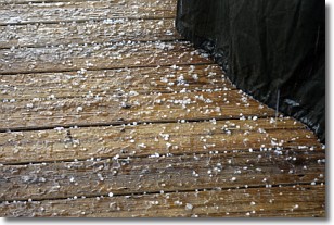
Weather Topic: What is Sleet?
Home - Education - Precipitation - Sleet
 Next Topic: Snow
Sleet is a form of precipitation in which small ice pellets are the primary
components. These ice pellets are smaller and more translucent than hailstones,
and harder than graupel. Sleet is caused by specific atmospheric conditions and
therefore typically doesn't last for extended periods of time.
The condition which leads to sleet formation requires a warmer body of air to be
wedged in between two sub-freezing bodies of air. When snow falls through a warmer
layer of air it melts, and as it falls through the next sub-freezing body of air
it freezes again, forming ice pellets known as sleet. In some cases, water
droplets don't have time to freeze before reaching the surface and the result is
freezing rain.
Next Topic: Snow
Current conditions powered by WeatherAPI.com


