Weather Alert in California
Flash Flood Warning issued February 16 at 3:18PM PST until February 16 at 5:00PM PST by NWS Los Angeles/Oxnard CA
AREAS AFFECTED: Los Angeles, CA
DESCRIPTION: FFWLOX The National Weather Service in Los Angeles/Oxnard has extended the * Flash Flood Warning for... Southwestern Los Angeles County in southwestern California... * Until 500 PM PST. * At 318 PM PST, Doppler radar and automated rain gauges indicated that another round of moderate to heavy rain is falling over the warned area. Between 1.8 and 2.7 inches of rain have fallen. Flash flooding is ongoing or expected to begin shortly. HAZARD...Flash flooding caused by heavy rain. Rock and mud slides. Minor debris flows at the Palisades and Franklin Burn Scars. SOURCE...Radar and automated gauges. IMPACT...Flash flooding of small creeks and streams, urban areas, highways, streets and underpasses as well as other poor drainage and low-lying areas. Rock and mud slides. Minor debris flows at the Palisades and Franklin Burn Scars. * Some locations that will experience flash flooding include... Thousand Oaks, Malibu, Woodland Hills, Encino, Santa Monica, Agoura Hills, Beverly Hills, North Hollywood, Hollywood, Universal City, Burbank, Griffith Park, Topanga State Park, Pacific Palisades, Calabasas, Brentwood, Malibu Creek State Park, Interstate 405 through the Sepulveda Pass and Bel Air.
INSTRUCTION: Turn around, don't drown when encountering flooded roads. Most flood deaths occur in vehicles. Stay away or be swept away. River banks and culverts can become unstable and unsafe. Please report observed flooding to local emergency services or law enforcement and request they pass this information to the National Weather Service when you can do so safely.
Want more detail? Get the Complete 7 Day and Night Detailed Forecast!
Current U.S. National Radar--Current
The Current National Weather Radar is shown below with a UTC Time (subtract 5 hours from UTC to get Eastern Time).

National Weather Forecast--Current
The Current National Weather Forecast and National Weather Map are shown below.

National Weather Forecast for Tomorrow
Tomorrow National Weather Forecast and Tomorrow National Weather Map are show below.

North America Water Vapor (Moisture)
This map shows recent moisture content over North America. Bright and colored areas show high moisture (ie, clouds); brown indicates very little moisture present; black indicates no moisture.

Weather Topic: What is Fog?
Home - Education - Cloud Types - Fog
 Next Topic: Fractus Clouds
Fog is technically a type of stratus cloud, which lies along the
ground and obscures visibility.
It is usually created when humidity in the air condenses into tiny water droplets.
Because of this, some places are more prone to foggy weather, such as regions
close to a body of water.
Fog is similar to mist; both are the appearance of water droplets suspended in
the air, but fog is the term applied to the condition when visibility is less than 1 km.
Next Topic: Fractus Clouds
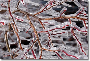
Weather Topic: What is Freezing Rain?
Home - Education - Precipitation - Freezing Rain
 Next Topic: Graupel
Freezing rain is a condition where precipitation which has fallen in the form of
water droplets reaches temperatures which are below freezing and freezes upon
coming into contact
with surface objects. The result of this precipitation is a glaze of ice which
can be damaging to plants and man-made structures. A severe onset of freezing
rain which results in a very thick glaze of ice is known as an ice storm.
Next Topic: Graupel
Current conditions powered by WeatherAPI.com


