Weather Alert in Illinois
Flood Warning issued March 11 at 10:19PM EDT until March 21 at 12:48AM EDT by NWS Indianapolis IN
AREAS AFFECTED: Edwards, IL; Gallatin, IL; Wabash, IL; White, IL; Gibson, IN; Knox, IN; Posey, IN
DESCRIPTION: ...The Flood Warning is extended for the following rivers in Indiana... East Fork White River at Shoals, near Bedford, near Rivervale, at Williams. White River at Edwardsport. ...The Flood Warning continues for the following rivers in Indiana... Illinois... East Fork White River at Seymour. White River at Elliston, Hazleton, and Petersburg. Wabash River at Mount Carmel. .Minor to moderate flooding continues on the White River and East Fork White River, and minor flooding continues on the tail end of the lower Wabash at Mount Carmel. The main crest on the White River is located at Petersburg, which will be followed by a secondary, lower crest Thursday or later from the most recent rainfall. The majority of locations on the East Fork River will see either similar secondary crests or minor bumps in the river level. The crest on the Wabash should reach Mount Carmel on Sunday. * WHAT...Minor flooding is occurring and minor flooding is forecast. * WHERE...Wabash River at Mount Carmel. * WHEN...Until Saturday, March 21. * IMPACTS...At 23.9 feet, Extensive lowland flooding in progress. In Wabash County Illinois, South Division Street and 1.5 miles of CR 1280 E remain flooded. High water blocks access to cabins along South Division Street and some nearby oil fields. * ADDITIONAL DETAILS... - At 8:45 PM EDT Wednesday /7:45 PM CDT Wednesday/ the stage was 21.8 feet. - Recent Activity...The maximum river stage in the 24 hours ending at 8:45 PM EDT Wednesday /7:45 PM CDT Wednesday/ was 21.8 feet. - Forecast...The river is expected to rise to a crest of 23.9 feet Sunday morning. It will then fall below flood stage Friday, March 20. - Flood stage is 19.0 feet. - http://www.weather.gov/safety/flood
INSTRUCTION: Turn around, don't drown when encountering flooded roads. Most flood deaths occur in vehicles. Be especially cautious at night when it is harder to recognize the dangers of flooding. Additional information is available at www.weather.gov/ind. The next statement should be issued Thursday afternoon by around 300 PM EDT /200 PM CDT/.
Want more detail? Get the Complete 7 Day and Night Detailed Forecast!
Current U.S. National Radar--Current
The Current National Weather Radar is shown below with a UTC Time (subtract 5 hours from UTC to get Eastern Time).

National Weather Forecast--Current
The Current National Weather Forecast and National Weather Map are shown below.

National Weather Forecast for Tomorrow
Tomorrow National Weather Forecast and Tomorrow National Weather Map are show below.

North America Water Vapor (Moisture)
This map shows recent moisture content over North America. Bright and colored areas show high moisture (ie, clouds); brown indicates very little moisture present; black indicates no moisture.

Weather Topic: What are Fractus Clouds?
Home - Education - Cloud Types - Fractus Clouds
 Next Topic: Freezing Rain
A fractus cloud (scud) is a fragmented, tattered cloud which has
likely been sheared off of another cloud. They are accessory clouds, meaning they
develop from parent clouds, and are named in a way which describes the original
cloud which contained them.
Fractus clouds which have originated from cumulus clouds are referred to as
cumulus fractus, while fractus clouds which have originated from stratus clouds
are referred to as stratus fractus. Under certain conditions a fractus cloud might
merge with another cloud, or develop into a cumulus cloud, but usually a
fractus cloud seen by itself will dissipate rapidly.
They are often observed on the leading and trailing edges of storm clouds,
and are a display of wind activity.
Next Topic: Freezing Rain
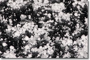
Weather Topic: What is Graupel?
Home - Education - Precipitation - Graupel
 Next Topic: Hail
Graupel is a form of precipitation that is created by atmospheric conditions
which cause supercooled water droplets to contact snow crystals and freeze to
their surface.
Sometimes known as soft hail or snow pellets, graupel is delicate and easily
destroyed by touch. Whereas hail usually falls during severe weather, graupel
doesn't require such conditions to form, and can form in mild precipitation
similar to situations which produce snowfall.
Next Topic: Hail
Current conditions powered by WeatherAPI.com


